Violent Tornadoes Tennis Ball Sized Hail and Destructive Winds Threatens Illinois Monday From Morning Through Evening Across Peoria Springfield Chicago and Beyond
ILLINOIS — A significant severe weather outbreak was forecast to impact a wide stretch of Illinois on Monday, carrying the potential for violent tornadoes, tennis ball-sized hail, and destructive winds across multiple regions of the state from the early morning hours through late evening, with timing and severity dependent heavily on how morning storm activity exits the region.
A morning round of thunderstorms was expected to move in after 3 AM and continue through the lunch hour, carrying wind, hail, and the possibility of an isolated tornado. Whether these storms clear by noon or linger into the afternoon represented the single most critical factor determining how severe the Monday afternoon and evening threat would ultimately become.
Two Scenarios Define the Outbreak Potential
If morning storms exit by noon and clearing develops across central Illinois, the afternoon hours were forecast to bring the most dangerous conditions of the day. Long-track tornadoes, massive hail, destructive winds, and embedded tornado risk within an organized storm system represented the full hazard suite for this scenario across the pay close attention region of central Illinois.
If morning storms lingered through 2 to 3 PM and cloud cover remained in place, the afternoon severe weather potential would be reduced, though isolated tornadoes and strong winds would still pose a meaningful threat across the region.
Timing Windows Vary Across the State
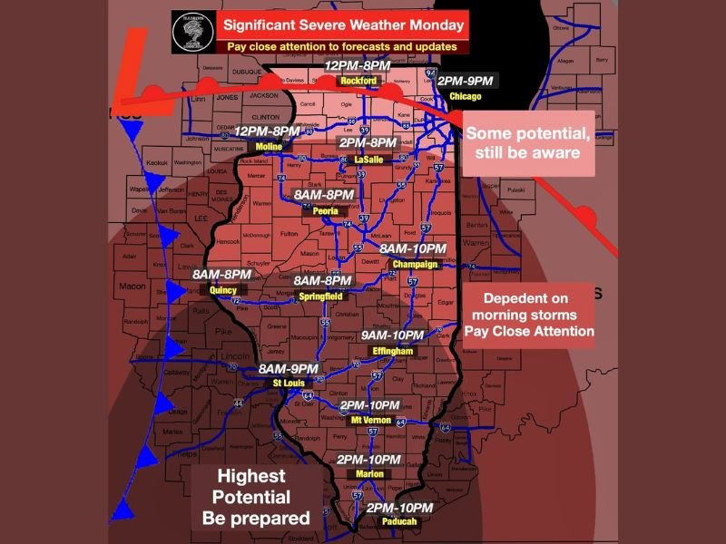
Severe weather timing windows varied significantly by location across Illinois. Peoria, Springfield, and Quincy faced an extended threat window running from 8 AM through 8 PM. Champaign carried a threat window from 8 AM through 10 PM while Effingham was flagged from 9 AM through 10 PM.
Further south, Mt. Vernon, Marion, and Paducah faced a narrower but significant afternoon and evening window from 2 PM through 10 PM. Chicago and Rockford carried afternoon threat windows beginning between noon and 2 PM, with the eastern portions of the state noted as dependent on morning storm behavior.
Highest Potential Zone Demands Preparation
Southern and central Illinois carried the highest severe weather potential designation for Monday. This region faced the greatest risk for significant severe weather including tornadoes potentially rated strong to violent and destructive winds capable of widespread structural damage.
Residents in the highest potential zone were urged to consider postponing travel plans and outdoor activities, ensure shelter plans were in place, and monitor weather updates continuously through the day.
School Safety and Community Awareness
With the threat window beginning as early as 8 AM across portions of central Illinois, early school dismissals and cancellation of after-school activities were considered possible depending on how the forecast evolved through the morning hours. Residents were advised to know their county location, monitor neighboring communities for incoming warnings, and maintain readiness to shelter well ahead of storm arrival throughout the Monday severe weather event.
For continuing coverage of severe weather events and critical storm analysis across the United States, visit SaludaStandard-Sentinel.com.