Tornado Watch and Supercell Threat With Very Large Hail Targets Arkansas Through 36-Hour Dangerous Weather Window Spanning Sunday Night Into Monday Evening
ARKANSAS — A tornado watch was issued for Benton and Washington counties in Arkansas expiring at Monday 12:00 AM CDT, as a complex and evolving severe weather pattern set the stage for a dangerous 36-hour window stretching from Sunday night through Monday evening across northern, western, and northeast Arkansas.
Futurecast radar imagery from Arkansas Weather Network showed storms with the potential to push into Arkansas as early as Sunday night at 9:30 PM, with morning storm activity possible by 6:30 AM Monday and isolated supercells expected to develop during the late Monday afternoon and evening hours.
Tornado Watch Already Posted as Storms Eye Arkansas
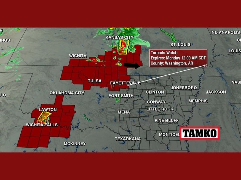
A tornado watch was already in place for Washington County, Arkansas as radar showed active severe storm cells across a broad swath stretching from Wichita and Tulsa through Kansas City and into the Fayetteville and Fort Smith corridors. The watch carried the possibility of expansion further into Arkansas if storms demonstrated a clear eastward movement into the state.
Radar captured at 5:49 PM Sunday showed intense storm activity across Oklahoma and Kansas, with tornado-warned cells near Lawton and Wichita Falls moving in a direction that raised concern for northern and western Arkansas communities through the overnight hours.
Sunday Night Into Monday Morning Brings Initial Threat
The immediate overnight concern centered on whether supercell development across Oklahoma would push organized storm activity into northern or western Arkansas. Wherever storms made landfall within the state, severe weather was considered likely, with the potential for very large hail and tornado development accompanying any supercell that established itself.
Late Sunday night storms were also flagged as a factor capable of influencing the Monday afternoon and evening threat, as morning storm activity across southern Missouri and northeast Arkansas could shape atmospheric conditions for the more significant round expected later in the day.
Monday Afternoon Supercells Carry Highest Impact Potential
The most significant threat window across the 36-hour period was identified for late Monday afternoon and evening, when isolated supercells were expected to develop. Any storm that formed during this window carried a high likelihood of producing very large hail and tornado activity, making situational awareness critical for residents across the affected region.
Futurecast imagery for Monday at 7:00 PM showed isolated supercell development pushing toward Clinton, Conway, and the broader central Arkansas region, underlining the geographic reach of the Monday evening threat.
Situational Awareness Urged Across the State
While not every Arkansas resident was expected to see rainfall during the 36-hour period, the storms that did develop carried serious hazard potential. Residents across northern, western, and northeast Arkansas were urged to maintain active access to weather warnings and have a clear shelter plan ready in the event a supercell moved into their area through the Sunday night to Monday evening timeframe.
For continuing coverage of severe weather events and critical storm analysis across the United States, visit SaludaStandard-Sentinel.com.