Significant Monday Snowstorm Targets Colorado Foothills and Wyoming I-80 Corridor With Pass Level Accumulations of 5 to 16 Inches Possible and Winter Driving Conditions Expected
DENVER, CO — The cold side of a major storm system arrives Monday, May 18, 2026, bringing significant snowfall to the Colorado foothills, the Continental Divide, northern mountains, and the I-80 corridor across southern Wyoming. Snow onset begins overnight before most accumulation occurs during Monday’s daylight hours, with the foothills west of I-25 from Gilpin County northward through Boulder and Larimer County into Wyoming’s Medicine Bow and Laramie Range identified as the bullseye zone for the heaviest totals.
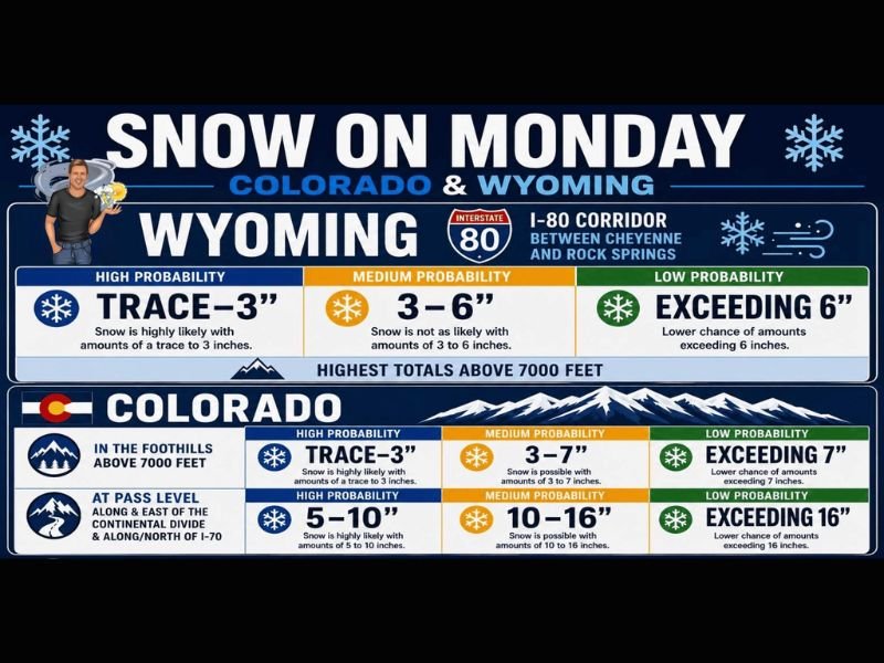
Wyoming I-80 Corridor Between Cheyenne and Rock Springs Faces Trace to 6 Inch Totals
Along Wyoming’s I-80 corridor between Cheyenne and Rock Springs, snow accumulations of a trace to 3 inches carry the highest probability, with 3 to 6 inch totals considered a medium probability outcome for the same zone. Amounts exceeding 6 inches carry a lower probability but remain possible, particularly at elevations above 7,000 feet where the highest totals across the Wyoming portion of the storm are expected to concentrate.
Winter driving conditions along the I-80 corridor are considered likely through Monday, and all motorists planning travel between Cheyenne and Rock Springs are strongly urged to check road conditions before departing and allow additional travel time throughout the day.
Colorado Foothills Above 7000 Feet Could See Up to 7 Inches With Higher Amounts at Pass Level
In the Colorado foothills above 7,000 feet, a trace to 3 inches of snow carries high probability, with 3 to 7 inches considered a medium probability outcome for the same elevations. At pass level along and east of the Continental Divide and along and north of I-70, the snowfall forecast becomes significantly more impressive, with 5 to 10 inches carrying high probability and 10 to 16 inches considered a medium probability outcome. Amounts exceeding 16 inches carry a lower but non-trivial probability at the highest pass level locations.
Overnight Onset Targets Higher Foothills and Continental Divide Before Spreading Monday
Snow will begin impacting the higher foothills, the Continental Divide, and the central and northern mountains overnight before the majority of accumulation occurs during Monday’s daylight hours. Residents across the Colorado Front Range foothills and all communities along and north of I-70 are urged to protect gardens and sensitive plants both Sunday night and especially Monday night as temperatures drop with the storm’s cold side fully in place.
For continuing coverage of winter storm forecasts and severe weather events across the United States, visit SaludaStandard-Sentinel.com.