Strong Tornadoes and Gorilla Hail Producing Supercells Target Arkansas, Kentucky, and Northeast Texas With Best Tornado Potential Across Central and Northeast Arkansas Tuesday Afternoon Into Evening
ARKANSAS — A dangerous severe weather outbreak was expected across the Mid South on Tuesday, May 5, 2026, with supercells capable of dropping gorilla hail and producing strong tornadoes threatening a broad corridor stretching from northeastern Texas through central and northern Arkansas and into western Kentucky, with the highest tornado potential concentrated along a terrain-enforced warm frontal zone across central and northeast Arkansas.
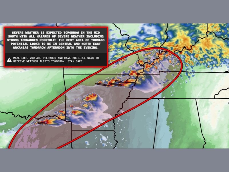
HRRR model simulated reflectivity imagery showed active and intense storm development projected across the Arkansas corridor during the Tuesday afternoon and evening timeframe, with the most significant severe weather threat zone outlined in red encompassing the full central and northeast Arkansas region.
All Hazards Severe Weather Expected Across the Mid South
The Tuesday severe weather setup was described as a full hazard event for the Mid South, with strong tornadoes, gorilla hail, and damaging winds all possible across the warned corridor. Gorilla hail, referring to extremely large hail exceeding baseball size, represented one of the most destructive elements of the anticipated supercell outbreak across the region.
The best area for tornado potential was specifically identified across central and northeast Arkansas during the Tuesday afternoon into evening hours, where the terrain-enforced warm frontal zone provided the most favorable environment for sustained and intense tornado-producing supercell development.
Threat Corridor Stretches From Texas Through Kentucky
The severe weather threat zone extended well beyond Arkansas, stretching from northeastern Texas in the southwest through the full Arkansas corridor and into western Kentucky to the northeast. The broad geographic footprint of the Tuesday outbreak reflected the scale of the atmospheric setup driving supercell development across the Mid South region.
Residents across the entire warned corridor from northeastern Texas through Arkansas and into western Kentucky were urged to have multiple ways to receive weather alerts active and shelter plans firmly in place well ahead of the Tuesday afternoon storm development.
For continuing coverage of severe weather events and critical storm analysis across the United States, visit SaludaStandard-Sentinel.com.
Author: Saluda Standard-Sentinel Team | Category: US News