Major Supercell and Tornado Outbreak Pattern Signals Junesanity 2.0 Across Central and Southern United States During June 10 to 16 Window
NORMAN, OK — A significant and potentially historic severe weather pattern is emerging in long range forecast models for the second and third week of June 2026, with CFSv2 Week 3 Accumulated Supercell Composite Parameter data pointing to an exceptionally favorable environment for supercell thunderstorm and tornado development across a broad corridor of the central and southern United States.
What the CFSv2 Model Data Is Showing
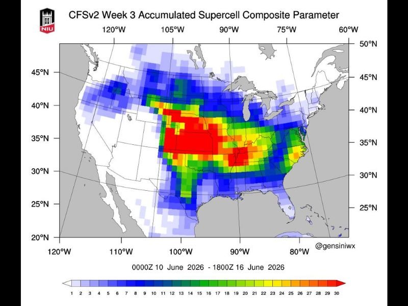
The CFSv2 Week 3 Accumulated Supercell Composite Parameter map, valid from June 10 through June 16, 2026, depicts an alarming concentration of high composite values across the central plains, southern plains, Mississippi Valley, and portions of the mid-South and mid-Atlantic regions.
The deepest red values on the composite map, representing the highest accumulated supercell parameter readings approaching and exceeding 25 to 30 on the scale, are centered across a zone spanning from roughly the Texas panhandle and Oklahoma northward through Kansas and into portions of the lower Missouri Valley, indicating an environment that could sustain repeated and intense supercell thunderstorm activity throughout this multi-day window.
Geographic Scope of the Elevated Threat
The elevated threat zone is remarkably broad in its geographic footprint, with significant composite parameter values extending well beyond the traditional tornado alley corridor.
Yellow and orange shading indicating elevated supercell potential reaches eastward across Missouri, Arkansas, Tennessee, and into the Carolinas and Virginia, while the northern extent of elevated values pushes into Iowa, Illinois, and Indiana. This expansive coverage suggests that a large portion of the eastern two thirds of the country could experience meaningful severe weather impacts during this period.
Junesanity Pattern Raising Concern
The emerging June pattern is drawing comparisons to significant historical severe weather outbreaks that have occurred during the month of June, a period that can produce some of the most intense and widespread tornado events of the entire year when atmospheric ingredients align favorably across the plains and Mississippi Valley.
June severe weather setups are particularly dangerous because moisture levels, wind shear, and atmospheric instability can all simultaneously reach peak values, creating an environment capable of supporting long track tornadoes and widespread damaging wind events across multiple states simultaneously.
Long Range Uncertainty Remains
It is critical to note that CFSv2 week three output carries considerable uncertainty and represents a potential pattern signal rather than a precise day by day forecast.
The actual timing, placement, and intensity of severe weather events within this window will become clearer as the period draws closer and higher resolution models begin capturing the details of the developing atmospheric setup. For continuing coverage of severe weather outlooks and tornado threat analysis across the United States, visit SaludaStandard-Sentinel.com.