StormNet AI Tool Flags Unusually Strong Tornado Probability Signal for Tennessee, Kentucky, Arkansas, Illinois and Missouri on Monday April 28 as Severe Weather Ramps Up Late April
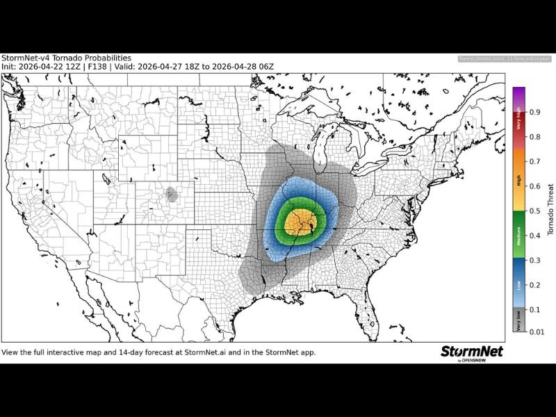
TENNESSEE — The StormNet v4 machine learning AI tornado probability tool is highlighting an unusually strong signal for tornado activity on Monday, April 28, with the highest risk concentrated across the Tennessee, Kentucky, Arkansas, Illinois, and Missouri tri-state corridor. The forecast, initialized on April 22, 2026 and valid from April 27 at 18Z through April 28 at 06Z, shows a well-defined bullseye of elevated tornado probability centered across this region that forecasters are describing as a notable and serious signal for the end of April.
Severe weather threats are expected daily next week, but Monday currently stands out as the highest risk day across the entire multi-day active period.
What the StormNet AI Tool Is Showing
The StormNet v4 tornado probability map shows a clearly defined concentric zone of increasing tornado threat centered over the TN/KY/AR/IL/MO region for Monday. The innermost zone displays yellow and orange shading, indicating medium to high tornado probability values between 0.4 and 0.6 for the core of the threat area.
Surrounding that core, green and blue shading extends outward across a broader region, indicating low to medium probability values across a wider swath of the central and southern United States. The sharp concentration of the highest probability values over the five-state corridor makes this a focused and well-defined threat rather than a broad, diffuse signal.
Supercells vs Squall Line Remains an Open Question
One of the key uncertainties forecasters are tracking heading into Monday is whether the severe weather event will take the form of isolated supercells or organize into a squall line. This distinction matters significantly for the tornado threat, as strong and violent tornadoes are generally more associated with discrete supercell thunderstorms than with squall line events.
Forecasters note that this question cannot be resolved yet given the distance of the event, but the StormNet AI signal remains unusually strong regardless of storm mode. Residents across the five-state threat zone should treat this as a serious potential tornado event and prepare accordingly as the week progresses.
Daily Severe Threats Expected Throughout the Week
Beyond Monday’s highlighted risk, forecasters are warning that severe weather threats will be present on a daily basis throughout next week as the pattern becomes increasingly active heading into the final days of April. This extended period of severe weather activity represents a significant ramp-up from the relatively quiet conditions that have dominated parts of the region in recent weeks.
Monday’s event currently stands out as the peak risk day of the week based on the StormNet AI signal, but residents across Tennessee, Kentucky, Arkansas, Illinois, and Missouri should remain weather aware throughout the entire week and not focus solely on Monday.
How Residents Should Prepare Now
With Monday’s tornado threat still several days away, residents across the five-state corridor have time to prepare thoroughly before the event arrives. Reviewing shelter locations, ensuring NOAA weather radios and alert apps are functioning, and developing a household severe weather plan are all critical steps to take now.
Forecasters will be refining the details of Monday’s event significantly over the coming days as model guidance improves and the storm mode question becomes clearer.
Are you tracking the developing tornado threat across Tennessee, Kentucky, Arkansas, Illinois and Missouri for Monday? Share your preparations and stay informed with the latest coverage at SaludaStandard-Sentinel.com.