Multiple Rounds of Loud Thunderstorms With Damaging Winds and Heavy Rainfall Alert Day Declared Across Kentucky Saturday With Storms Expected From 9AM Through 8PM
LOUISVILLE, KY — Weather Now Kentucky has declared an Alert Day for Saturday across the region as multiple rounds of loud thunderstorms are expected to impact the area between 9AM and 8PM Eastern Time. The day is not anticipated to be a singular storm event but rather a prolonged series of thunderstorm rounds bringing damaging winds, heavy rainfall, and hail potential across portions of Kentucky and surrounding areas through the evening hours.
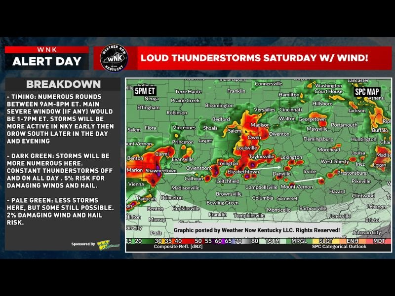
Numerous Thunderstorm Rounds Expected Between 9AM and 8PM With Peak Severe Window From 1PM to 7PM
Forecast timing indicates storms will fire in numerous rounds throughout the day, with the main severe weather window, if any warnings are issued, expected between 1PM and 7PM Eastern Time. Storm activity will be more concentrated across Northern Kentucky early in the day before growing southward through the afternoon and evening hours as the overall pattern expands across the region.
The multi-round nature of Saturday’s setup means some areas could experience several small thunderstorm passages throughout the day while other locations may see little to no activity at all, making this a highly variable and localized storm day across the affected zone.
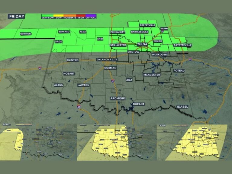
Dark Green Zones Face Highest Storm Coverage and 5 Percent Wind and Hail Risk
Areas shaded in dark green on the forecast map face the greatest storm coverage Saturday, where constant thunderstorm activity is possible on and off throughout the entire day. These zones carry a 5 percent risk for damaging winds and hail, representing the higher end of the overall low risk profile associated with this Alert Day across Kentucky.
Radar imagery shows the heaviest current storm returns concentrated across the Evansville, Owensboro, Elizabethtown, and Louisville corridors, with intense red and orange reflectivity values confirming the presence of active and ongoing convection across these areas as the broader Saturday storm pattern continues to develop.
Pale Green Areas See Lower But Still Possible Storm Activity Through the Day
Communities falling within the pale green zones on the forecast map face a lower but still meaningful chance of thunderstorm activity Saturday, with a 2 percent risk for damaging winds and hail across these areas. While storm coverage will be less frequent and intense compared to the dark green zones, residents across pale green areas should not dismiss the storm potential entirely as isolated cells remain possible throughout the day.
Very heavy rainfall is expected with some of the stronger storm cells regardless of location, making localized flooding a secondary concern for low lying areas and poor drainage zones across both the dark and pale green portions of the forecast region.
Overall Low End Risk Day but Severe Warnings Possible Mainly for Winds
Despite the Alert Day designation, forecasters characterize Saturday as an overall low end risk day with only a few severe thunderstorm warnings possible, primarily driven by wind rather than tornado activity. No real tornado threat is anticipated with this setup, offering some reassurance to residents across the region while still underscoring the need for awareness throughout the prolonged storm window.
The much needed rainfall accompanying Saturday’s thunderstorm rounds will be a welcome development for drought stressed areas across Kentucky, even as residents remain weather-aware through the 8PM end of the primary storm window.
For continuing coverage of severe weather alerts and storm forecasts across the United States, visit SaludaStandard-Sentinel.com.