Disorganized Tropical Moisture Flaring Over the Gulf With Higher Downpour Chances Arriving in Southeast Texas Friday and Saturday Despite Low Organization Threat
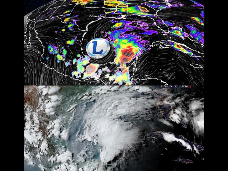
HOUSTON, TX — A disorganized but visually impressive area of tropical moisture is flaring over the Gulf of Mexico Monday evening, with satellite imagery showing active storm development across the Gulf basin that while appearing ominous on initial inspection is being assessed by forecasters as a highly sheared and disorganized system unlikely to develop beyond a messy collection of tropical moisture given the unfavorable atmospheric conditions currently in place across the region.
High Wind Shear Limits Organization Potential
The storm activity visible across the Gulf on Monday evening satellite imagery is occurring within a highly sheared atmospheric environment, meaning strong winds at different levels of the atmosphere are working against the type of organized and sustained rotation necessary for a tropical system to develop into a named storm or structured tropical cyclone.
True color satellite imagery captured at 6:30 PM Monday shows a broad and sprawling area of cloud cover and convective activity across the western Gulf basin, but the disorganized and fragmented nature of the cloud mass reflects the disruptive influence of wind shear preventing the moisture from consolidating into any coherent tropical structure despite the visually active appearance of the satellite presentation.
Tropical Moisture Still Heading Toward Southeast Texas
While formal tropical development remains unlikely given the current sheared environment, the abundant tropical moisture associated with the Gulf system is still on track to reach Southeast Texas by Friday and Saturday, when forecasters expect significantly elevated chances of heavy tropical downpours across the Houston metropolitan area and surrounding communities regardless of whether any organized low pressure system develops.
The arrival of higher tropical moisture levels will combine with an already unstable atmosphere to produce heavy rainfall potential across Southeast Texas during the Friday and Saturday window, with the primary concern being rainfall accumulation and localized flooding rather than any wind or tropical storm impacts.
Two Storm Rounds Possible Before Moisture Arrives
Even before the direct tropical moisture surge reaches Southeast Texas later in the week, the Houston area faces two potential rounds of storm activity on Tuesday as the broader unstable environment associated with the Gulf moisture field begins influencing the regional weather pattern ahead of the main moisture arrival.
Residents across the greater Houston area and Southeast Texas are encouraged to keep their umbrella handy through the entire week as multiple rounds of rainfall and storm activity are expected before conditions stabilize following the tropical moisture passage during the weekend period. For continuing coverage of Gulf tropical developments and Southeast Texas weather impacts, visit SaludaStandard-Sentinel.com.