Softball Size Hail and Tornado Strike West-Central Texas as Three Major Storm Clusters Bring Baseball Size Hail Near Hamilton and Increasing Damaging Wind Threat Toward DFW Metro
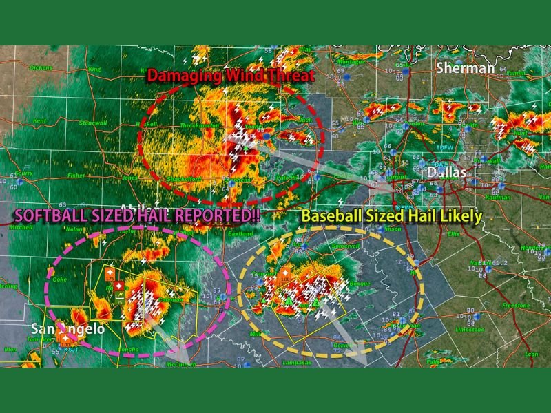
SAN ANGELO, TX — Three large and mature storm clusters are simultaneously producing catastrophic severe weather across West-Central Texas, with softball size hail confirmed northeast of San Angelo, baseball size hail likely near Hamilton, a tornado reported across the region, and a rapidly increasing damaging wind threat now advancing toward the Dallas-Fort Worth Metroplex as all three storm systems track southeastward through the state.
Softball Size Hail Confirmed Northeast of San Angelo
Softball size hail, measuring approximately 4.5 inches in diameter, has been confirmed northeast of San Angelo, representing one of the largest and most destructive hail sizes that can be produced by a severe thunderstorm across the southern plains. Hail of this magnitude causes immediate catastrophic damage to anything in its path, completely destroying vehicle exteriors, punching through roofing structures, shattering windows, and posing a direct life-threatening danger to any person caught outdoors.
The storm producing softball size hail northeast of San Angelo is described as very dangerous and continues tracking southeastward, expanding the threat zone with every passing minute.
Baseball Size Hail Likely Near Hamilton
A second dangerous storm of comparable intensity is active near Hamilton, Texas, where baseball size hail measuring approximately 2.75 inches is considered likely as the storm tracks southeastward with a similar threat profile to the San Angelo supercell. The simultaneous presence of two violent hail-producing storms across West-Central Texas represents an extraordinary and dangerous severe weather episode for the region.
Radar imagery shows intense storm returns across both the San Angelo and Hamilton storm clusters, with the most extreme radar signatures confirming the destructive hail cores within each system.
Damaging Wind Threat Increasing for DFW Metro
Beyond the hail-producing storms to the west, the damaging wind threat is explicitly flagged as increasing for the Dallas-Fort Worth Metroplex as the broader storm system advances southeastward. A third storm cluster shown on radar northwest of Dallas carries the primary wind threat for the metro area, with the potential for damaging gusts impacting millions of DFW residents as the afternoon severe weather episode continues evolving across the region.
All residents across West-Central Texas, the Hamilton area, and the DFW Metroplex are urged to take immediate shelter and keep emergency alert systems active throughout the ongoing severe weather event.
For continuing coverage of severe weather events and critical storm analysis across the United States, visit SaludaStandard-Sentinel.com.