Strong Tuesday Afternoon Storms Bring Hail Damaging Winds and Heavy Downpours to Dallas and North Texas as Cold Front Arrives With Intense Radar Returns Across the Metroplex
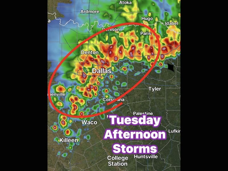
DALLAS, TX — A cold front arriving Tuesday afternoon is driving strong and organized storm activity across the Dallas and North Texas metroplex, bringing hail, damaging winds, lightning, and heavy downpours to communities across a broad corridor stretching from Denton and Denison southward through Dallas and Corsicana. Radar imagery shows intense red, orange, and purple reflectivity returns concentrated directly over and around the Dallas metro area as the cold front pushes through the region during the afternoon hours.
Cold Front Drives Strong Storms Ahead of and Along the Frontal Boundary
The arriving cold front is generating strong storm development both ahead of and along the frontal boundary as it moves through North Texas on Tuesday afternoon. This dual storm mode, with storms firing ahead of the front as well as directly along it, creates a prolonged and widespread severe weather window for communities across the Dallas and Fort Worth metroplex and surrounding areas including Denton, Denison, Paris, and Corsicana throughout the afternoon hours.
Radar returns across the circled zone centered over Dallas show multiple intense storm cores with deep red and purple signatures indicating the heaviest precipitation and most significant storm activity concentrated directly over one of the most densely populated metropolitan areas in the state.
Hail Damaging Winds Lightning and Heavy Downpours Are the Primary Hazards
The primary hazards associated with Tuesday afternoon’s storm activity include hail, damaging winds, frequent lightning, and very heavy downpours across the affected North Texas corridor. These hazard types across a metropolitan area the size of Dallas create significant public safety concerns, particularly for motorists on area highways and freeways where reduced visibility from heavy downpours and hydroplaning from rapid rainfall accumulation present serious driving dangers.
Communities across Denton, Dallas, Corsicana, and the broader circled zone on the radar display should expect conditions to deteriorate rapidly as the cold frontal storm line pushes through the region during the peak afternoon severe weather window.
Storm Activity Extends From Ardmore Oklahoma Southward Through the Metroplex
The broader storm complex visible on radar extends from the Ardmore and Atoka areas of southern Oklahoma southward through the entire Dallas metroplex and further south toward Waco and Killeen, reflecting the significant geographic scale of the cold frontal storm system impacting North Texas on Tuesday. Communities from Denison and Paris along the Red River southward through Tyler and Corsicana all fall within the active storm zone as the front continues its progression through the region.
Residents across all of North Texas are urged to remain weather aware through Tuesday afternoon, delay non-essential travel until the frontal storm line clears the area, and seek shelter immediately if thunder is heard or lightning is observed in their vicinity. For continuing coverage of severe weather and storm forecasts across the United States, visit SaludaStandard-Sentinel.com.