Storms Targeting the Florida Peninsula Tuesday as SPC Expands Level 1 Risk Coast to Coast With Possible Upgrade to Level 2 as Gulf Moisture Fuels Development From Tampa Through Orlando and East Coast
ORLANDO, FL — A stormy Tuesday is developing across the Florida Peninsula as the Storm Prediction Center expands its severe weather outlook to a Level 1 Marginal Risk covering the state coast to coast, with forecasters noting the possibility of an upgrade to a Level 2 Slight Risk for some portions as a frontal line dips further south and additional Gulf moisture provides extra fuel for storm development across central and eastern Florida throughout the day.
SPC Expands Risk Across Florida With Possible Upgrade
The Storm Prediction Center has expanded its severe weather outlook to cover the Florida Peninsula coast to coast at the Level 1 Marginal Risk threshold, reflecting a meaningful and broad severe weather potential across the state on Tuesday. The explicit mention of a possible upgrade to Level 2 Slight Risk for some areas indicates that atmospheric conditions could support a more organized and impactful storm setup than the baseline outlook currently reflects.
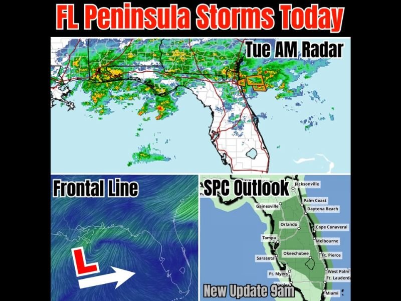
Tuesday morning radar imagery shows active shower and storm activity already concentrated along the northern tier of Florida from the Gulf Coast through the Atlantic side, with warning boxes visible along the northeast Florida coast near Daytona Beach indicating ongoing severe weather activity during the morning hours.
Frontal Line Dipping South With Gulf Moisture Adding Fuel
The frontal boundary driving Tuesday’s storm development is depicted dipping further southward than initially anticipated, with a low pressure center positioned to the southwest and pushing the frontal line deeper into the Florida Peninsula. This southward dip allows the frontal boundary to interact with additional moisture streaming in off the Gulf of Mexico, providing the extra atmospheric fuel needed to support more robust and potentially severe storm development across the state.
The combination of frontal forcing and Gulf moisture represents a classic Florida severe weather setup capable of producing organized convection across a broad geographic area simultaneously.
Storms Developing Middle State and Pushing East
The primary storm development is expected to initiate across the middle portions of the Florida Peninsula before pushing eastward through the afternoon and evening hours. Communities along the central Florida corridor including Orlando, Tampa, Gainesville, and Okeechobee are positioned in the zone of highest storm development probability, with the activity subsequently advancing toward the Atlantic Coast communities of Daytona Beach, Melbourne, Fort Pierce, and West Palm Beach as the day progresses.
Residents across the entire Florida Peninsula are urged to monitor updated SPC outlooks through the 9 AM and subsequent forecast discussions as storm potential continues evolving throughout Tuesday.
For continuing coverage of severe weather events and critical storm analysis across the United States, visit SaludaStandard-Sentinel.com.