Severe Storms Heavy Rain and Flash Flooding Threaten Ohio Valley to Central Plains Sunday as Heat Builds Across Southern Plains Into Monday
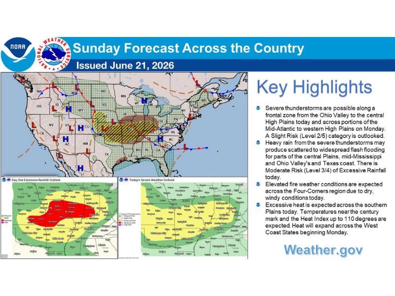
ST. LOUIS, MO — An active weather pattern continues across the center of the nation Sunday, with severe thunderstorms and heavy rain threatening a broad frontal zone from the Ohio Valley to the central High Plains, while excessive heat builds across the southern Plains and locally critical fire weather conditions develop across the Four Corners region.
Severe Storms Stretch From the Ohio Valley to the Plains
The Storm Prediction Center has placed a Slight Risk, or Level 2 of 5, for severe thunderstorms along a frontal boundary extending from the Ohio Valley westward into the central High Plains today. This severe threat is expected to shift Monday, expanding into portions of the Mid-Atlantic and western High Plains as the active pattern continues across the country.
Communities across Missouri, Illinois, and the surrounding Ohio Valley region should remain alert for the potential of strong to severe thunderstorms capable of producing damaging winds and heavy rainfall as the system tracks through the area.
Moderate Risk for Flash Flooding Across Multiple Regions
Heavy rain from the severe thunderstorms may produce scattered to widespread flash flooding across portions of the central Plains, mid-Mississippi Valley, Ohio Valley, and the Texas coast. The Weather Prediction Center has assigned a Moderate Risk, or Level 3 of 4, for excessive rainfall today, with the highest-risk zone centered around the St. Louis and Springfield areas.
This elevated flood risk reflects the potential for repeated rounds of heavy rainfall to fall over the same areas, a pattern capable of producing rapid water rises on area roads and waterways across the affected region.
Heat and Fire Weather Concerns Build to the West
Excessive heat is expected across the southern Plains today, with temperatures approaching the century mark and heat index values reaching as high as 110 degrees in the hardest-hit areas. This dangerous heat is forecast to expand into the West Coast states beginning Monday as the broader pattern shifts.
Meanwhile, elevated fire weather conditions are expected across the Four Corners region today, driven by a combination of dry air and gusty winds that will heighten the risk of rapid fire spread across that part of the Southwest.
For continuing coverage of severe weather events and national forecast trends across the United States, visit SaludaStandard-Sentinel.com.