Scattered to Numerous Pop Up Storms Threatening Indiana Monday With Flooding as the Primary Concern and Highs Reaching the Upper 80s Across the Northern Half of the State
INDIANAPOLIS, IN — Indiana is facing a deceptively active Monday, June 8, with partly sunny skies giving way to scattered to numerous pop-up thunderstorms developing statewide through the afternoon and evening hours, with flooding emerging as the top concern due to slow storm movement and one or two storms capable of producing gusty winds.
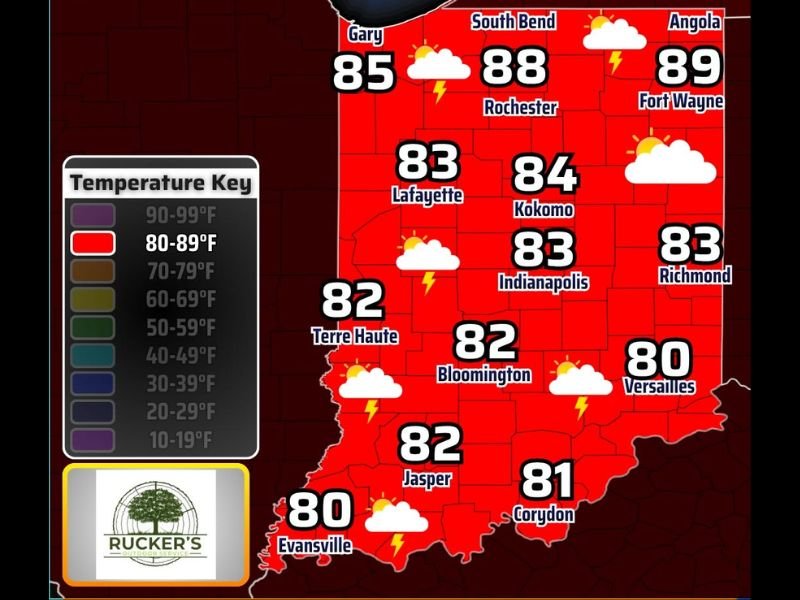
Statewide Temperatures Monday
High temperatures across Indiana on Monday will range from the low 80s in the south to the upper 80s across the northern half of the state. Fort Wayne and Angola will top out near 89°F, South Bend at 88°F, and Kokomo reaching 84°F. Indianapolis and Richmond will both sit at 83°F, while Terre Haute, Bloomington, and Jasper settle in the low 80s. Evansville anchors the southwest at 80°F and Versailles comes in at 80°F across the southeast.
The entire state falls within the 80 to 89°F temperature range, making this a uniformly warm June day from border to border.
The Storm Threat
While widespread severe weather is not anticipated, scattered to numerous pop-up storms are expected to develop across all of Indiana through the day under partly cloudy skies. The slow movement of these storms is the primary driver of concern, as training thunderstorms moving over the same areas repeatedly can deposit several inches of rainfall in a short period, triggering flash flooding in low-lying areas and poor drainage zones.
One or two of the stronger storms could produce gusty winds as an additional hazard, though the overall severe weather risk remains isolated rather than widespread across the state.
Flooding the Top Concern
Forecasters are emphasizing flooding as the highest concern for Monday’s storm activity statewide. Residents should avoid driving through flooded roadways regardless of how shallow the water appears, as just inches of moving water can sweep a vehicle off course. Those in flood-prone areas should monitor conditions closely through the afternoon and into the evening hours.
Winds outside of storms will remain breezy at 10 to 20 mph with gusts reaching 25 mph through the day.
What to Watch For
Residents across Indianapolis, Fort Wayne, South Bend, and all points between should keep weather apps updated and alerts active throughout Monday. Storm development could be rapid under partly sunny skies, giving little visual warning before heavy rain arrives. For continuing coverage of Indiana weather and storm events across the United States, visit SaludaStandard-Sentinel.com.