Historic CIG 2 Severe Weather Risk Issued for the First Time in SPC History Targeting Central Plains to Great Lakes Monday With EF3 Tornadoes and Giant Hail Threatening Millions
KANSAS CITY, MO — For the first time in Storm Prediction Center history, a CIG 2 risk designation has been issued on a Day 3 severe weather outlook, marking an unprecedented milestone in meteorological forecasting as an extraordinarily dangerous severe weather setup targets a massive corridor stretching from the Central Plains through the Great Lakes region on Monday, May 18, 2026. The outlook, updated at 4:22 AM Eastern Time on May 16, 2026, highlights the risk of intense EF3 or stronger tornadoes and giant hail measuring 2 to 4 inches in diameter across the affected zone.
Historic CIG 2 Designation Marks an Unprecedented Moment in SPC Forecasting
The CIG 1 through 3 outlook style was introduced by the Storm Prediction Center in March 2026 as a new framework for communicating extreme severe weather potential in extended range forecasts. The issuance of a CIG 2 designation on a Day 3 outlook has never occurred before in SPC history, underscoring the extraordinary confidence forecasters have in the severity and scale of Monday’s developing severe weather threat across the Central Plains and Upper Midwest.
This historic designation reflects not only the intensity of the expected storm hazards but also the unusually high forecast confidence this far in advance, a combination that sets Monday’s event apart from the vast majority of severe weather outbreaks in modern meteorological records.
EF3 Tornadoes and Giant Hail of 2 to 4 Inches Drive the Historic Risk Level
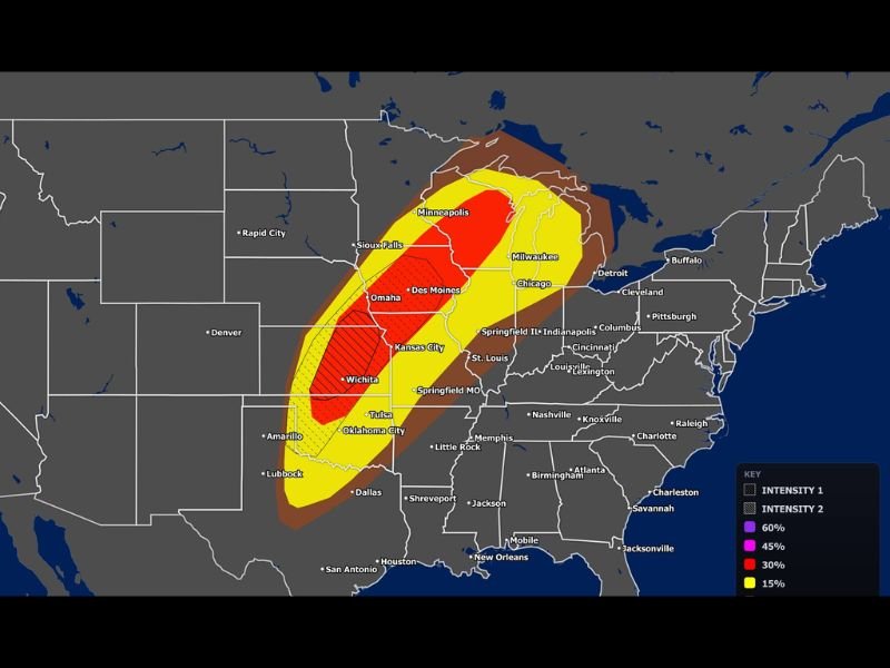
The primary hazards driving the unprecedented CIG 2 designation are intense tornadoes rated EF3 or stronger and giant hail ranging from 2 to 4 inches in diameter. These hazard types at the levels being forecast represent a life threatening and catastrophic severe weather scenario for communities falling within the highest probability zones on Monday’s outlook map.
The 60 percent severe weather probability zone, shown in deep red on the outlook map, covers a concentrated corridor encompassing Omaha, Kansas City, Wichita, Des Moines, and surrounding communities across Nebraska, Iowa, Kansas, and Missouri, placing millions of residents in the direct path of what forecasters are describing as an exceptionally dangerous outbreak.
Probability Map Shows Sprawling Threat From Oklahoma City to Minneapolis
The severe probability map issued for Monday shows an enormous geographic footprint stretching from Oklahoma City and Tulsa in the south northward through Kansas City, Omaha, Des Moines, Minneapolis, and Milwaukee. The 30 percent probability zone extends further east through Chicago, Indianapolis, and Columbus, while the broader 5 percent brown shading covers an even wider swath of the central and eastern United States from the Southern Plains to the Great Lakes.
The sheer geographic scale of this outlook combined with the historic CIG 2 designation means tens of millions of people across multiple states face some level of severe weather risk on Monday, with the greatest and most catastrophic potential concentrated across the Central Plains corridor.
Residents Across the Central Plains and Upper Midwest Must Prepare Immediately
Given the historic and unprecedented nature of this severe weather outlook, residents across Oklahoma, Kansas, Nebraska, Iowa, Missouri, Minnesota, Wisconsin, and Illinois are strongly urged to begin severe weather preparations immediately. Having a tested shelter plan, multiple warning notification methods, and a clear understanding of the tornado threat this event carries are all essential steps for every household within the outlined risk zones.
Monday’s event has the potential to be one of the most significant and historically notable severe weather outbreaks in recent decades, and the time to prepare is now, well before the storms arrive across the Central Plains and Upper Midwest.
For continuing coverage of historic severe weather events and critical storm forecasts across the United States, visit SaludaStandard-Sentinel.com.