Severe Thunderstorm Watch Active Until 11 AM as Storm Line Crosses Red River Into North Texas Bringing 55 MPH Winds Flash Flooding and Frequent Lightning
DALLAS, TX — A line of strong thunderstorms crossed the Red River from southern Oklahoma into North Texas early Monday morning, with a Severe Thunderstorm Watch in effect until 11 AM as the storm complex produced wind gusts up to 55 mph, frequent lightning, heavy rainfall, and flash flooding rain rates of 2 inches per hour along its leading edge.
Storm Line Pushes Southeast Through North Texas
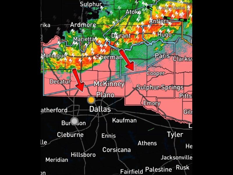
As of 5:20 AM, the line of severe-capable thunderstorms was continuing to move southeast across the region, tracking from areas near Sherman and Decatur southward toward McKinney, Plano, and the broader Dallas-Fort Worth Metroplex. Radar showed the most intense cells concentrated along the leading edge of the line, with heavy rainfall and lightning strikes widespread across the impacted corridor.
The strongest storms were expected to impact counties along and north of Highway 380 through the early morning hours before gradually weakening as the system moved farther south into the Metroplex.
Multiple Hazards Accompany the Leading Edge
The leading edge of the storm complex was producing a combination of hazards simultaneously, with wind gusts reaching up to 55 mph capable of downing tree limbs and damaging unsecured outdoor objects. Flash flooding was also a concern given rainfall rates reaching 2 inches per hour, a rate that can quickly overwhelm drainage systems and cause rapid water rises on roadways.
Frequent lightning accompanied the heavier storm cells throughout the complex, adding an additional hazard for anyone outdoors or traveling through the affected area during the peak impact window.
Primary Impact Window Falls Between 5 AM and 9 AM
Forecasters identified the main timeframe for impacts as 5 AM through 9 AM Monday morning, placing the most significant activity directly during the morning commute hours across North Texas. Residents across the Dallas-Fort Worth area and communities north of Highway 380, including McKinney, Plano, Sherman, and Decatur, were urged to allow extra travel time and secure any loose outdoor objects before heading out.
Storms Expected to Weaken Heading Into the Metroplex
As the line continues pushing south into the heart of the Dallas-Fort Worth Metroplex, gradual weakening is expected, though heavy rain and gusty winds may still accompany the trailing portions of the complex as it moves through the urban core.
For continuing coverage of severe weather events and storm impacts across the United States, visit SaludaStandard-Sentinel.com.