Severe Weather and Heavy Rain Risk Returns Across Mississippi and Surrounding Region Wednesday Night Through Friday Targeting Jackson, Hattiesburg, Meridian, and McComb
JACKSON, MS — Severe weather risk was returning to Mississippi and surrounding areas beginning Wednesday night and continuing through Friday, with storm activity initially focused north of the southern six counties of Mississippi before gradually sliding southward through late Wednesday night into Thursday, bringing the threat of severe weather and heavy rain across a broad multi-day window.
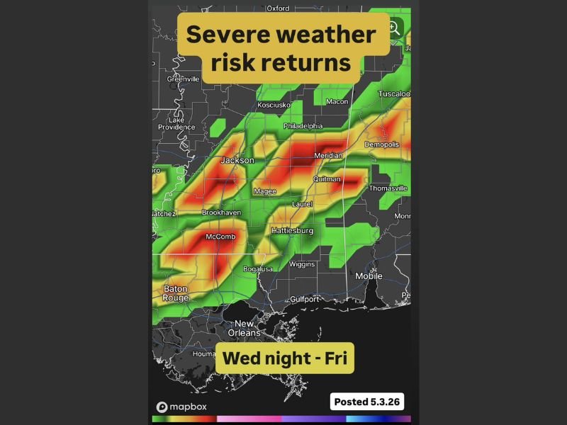
Radar imagery posted May 3, 2026 showed the projected storm footprint covering a wide corridor from Jackson, Kosciusko, and Meridian through Hattiesburg, Laurel, McComb, Brookhaven, and toward the Gulf Coast communities of Gulfport and Mobile as the storm system progressed southward through the Wednesday night to Friday timeframe.
Storm Risk Slides South Through the Week
The storm system was expected to begin its impact north of the southern six Mississippi counties before gradually pushing southward as Wednesday night transitioned into Thursday. The sliding nature of the threat meant communities across central and northern Mississippi faced the earliest severe weather window while southern communities including Hattiesburg, McComb, Bogalusa, and Gulfport would see storm activity arrive later in the Thursday through Friday period.
Details on the exact placement of the greatest risk zone were still being refined, with forecasters noting a few additional days were needed to pin down where the highest impact area would ultimately set up across the region.
Severe Weather and Heavy Rain Both Possible
The mid-week storm system carried the dual threats of severe weather and heavy rainfall across the affected Mississippi corridor. Communities including Jackson, Meridian, Laurel, Quitman, Magee, Hattiesburg, and Wiggins all fell within the projected storm footprint, with Baton Rouge, New Orleans, and Mobile also positioned within the broader outer edges of the developing weather system through the Wednesday night to Friday window.
Residents across Mississippi were advised to enjoy the beautiful start to the week while monitoring updated forecasts as the Wednesday night through Friday severe weather system came into clearer focus.
For continuing coverage of severe weather events and critical storm analysis across the United States, visit SaludaStandard-Sentinel.com.