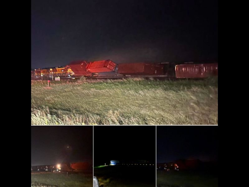
Severe Winds Tip Over Several Double Stacked Container Train Cars East of Woodward Oklahoma in Dramatic Demonstration of Storm Intensity Overnight
WOODWARD, OK — Several double-stacked container train cars were tipped over by severe winds approximately 2 to 3 miles east of Woodward, Oklahoma overnight, in a dramatic demonstration of the destructive power of the severe weather event that swept through the region, leaving a significant scene of displaced and overturned rail cars along the track corridor.
Severe Winds Derail Multiple Double-Stacked Cars
The incident involved multiple double-stacked container train cars, a configuration that places two intermodal shipping containers on top of each other and significantly raises the center of gravity and wind profile of each rail car. This type of rolling stock is particularly vulnerable to extreme wind events, as the tall, wide surface area of stacked containers can catch severe gusts much like a sail.
Images from the scene showed several cars displaced and overturned along the track, with the containers visibly separated and knocked off their flatcar bases, illustrating the extreme force of the winds responsible for the incident. Emergency vehicles were visible at the scene responding to the derailment through the overnight hours.
Location Places Incident East of Woodward
The overturned cars were located approximately 2 to 3 miles east of Woodward, placing the incident in a rural stretch of northwestern Oklahoma track corridor. The remote nature of the location is consistent with the open terrain that characterizes much of this part of Oklahoma, where unobstructed wind flow across flat land can allow severe gusts to reach and sustain extreme speeds without the buffering effect of trees or structures.
Extent of Damage and Cargo Status Under Assessment
The full extent of the derailment, including the number of cars affected and the status of any cargo carried by the train, was not immediately available. Emergency crews on scene were working to assess the situation in the overnight hours following the incident.
Severe Weather Pattern Responsible for the Damage
The wind event responsible for tipping the train cars was part of a broader severe weather pattern that moved through Oklahoma overnight, producing damaging winds across multiple communities in the northwestern part of the state as the storm complex tracked through the region.
For continuing coverage of severe weather damage and storm impacts across the United States, visit SaludaStandard-Sentinel.com.