Damaging Wind Gusts Heavy Rain and Brief Tornado Possible Across North Georgia Monday as Cold Front Pushes Through Targeting Areas North of Interstate 20
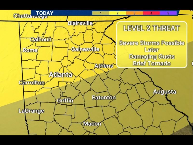
ATLANTA, GA — A cold front is expected to push across North Georgia later Monday, bringing a Level 2 of 5 severe weather threat to a broad swath of the state as locally heavy rain, damaging wind gusts, and a brief spin-up tornado cannot be ruled out, particularly across communities north of Interstate 20 where the highest storm potential is concentrated.
Cold Front Drives Afternoon Storm Development
A cold front approaching from the west will interact with a warm, unstable atmosphere across North Georgia through the afternoon hours, increasing the likelihood of strong to severe thunderstorms developing across the region. The highest chance of a strong or severe storm will be confined to areas north of Interstate 20, placing communities including Rome, Calhoun, Gainesville, and Athens in the primary threat zone.
Chattanooga and surrounding areas just to the northwest also fall within the broad severe weather corridor, as the cold front tracks across the northern tier of Georgia through the afternoon.
Damaging Winds and Heavy Rain Are the Primary Threats
The main storm hazards for Monday include locally heavy rain capable of producing localized flooding and damaging wind gusts that could bring down tree limbs and cause scattered power outages. These two threats are expected to be the most widespread impacts across the Level 2 risk area as storms develop and organize along and ahead of the advancing cold front.
The Atlanta metro area, including Carrollton, Griffin, and surrounding suburbs, falls within the Slight Risk zone, with storm activity possible as the front continues its southward progression through the afternoon and evening hours.
Brief Tornado Cannot Be Ruled Out in Northwest Georgia
Forecasters noted a brief, spin-up tornado cannot be ruled out with this setup, particularly across far northwestern Georgia where the cold front interaction and surface boundaries create the most favorable conditions for brief rotation. While the tornado threat is not the primary concern with this event, residents across the northwest corner of the state are urged to remain weather aware through the afternoon hours.
Storm Timing Runs Through the Afternoon and Evening
The main window for severe storm potential is expected to run through the afternoon and into the evening hours as the cold front tracks southward across the state, eventually pushing through the central Georgia counties including Eatonton, Macon, and LaGrange later in the day.
For continuing coverage of severe weather events and storm impacts across the United States, visit SaludaStandard-Sentinel.com.