Several Significant Severe Weather and Tornado Days Signal Major Pattern Change Across Illinois Missouri Indiana Iowa Arkansas and Oklahoma During May 20 to 26
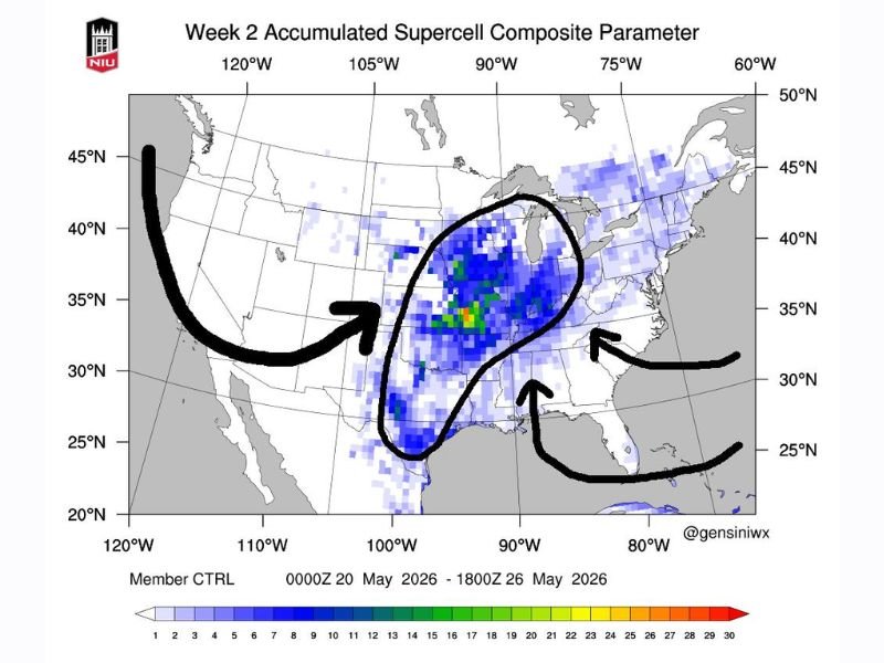
CHICAGO, IL — A major atmospheric pattern change is bringing several significant days of severe weather and tornado setups to the Midwest and surrounding states during the May 20 to 26, 2026 period, with Illinois, Missouri, Indiana, western Kentucky, Iowa, Arkansas, and Oklahoma all identified as primary targets as the Week 2 Accumulated Supercell Composite Parameter model from Northern Illinois University shows the highest severe weather potential concentrated directly over this multi-state corridor.
Major Pattern Change Amplifying Into Next Week
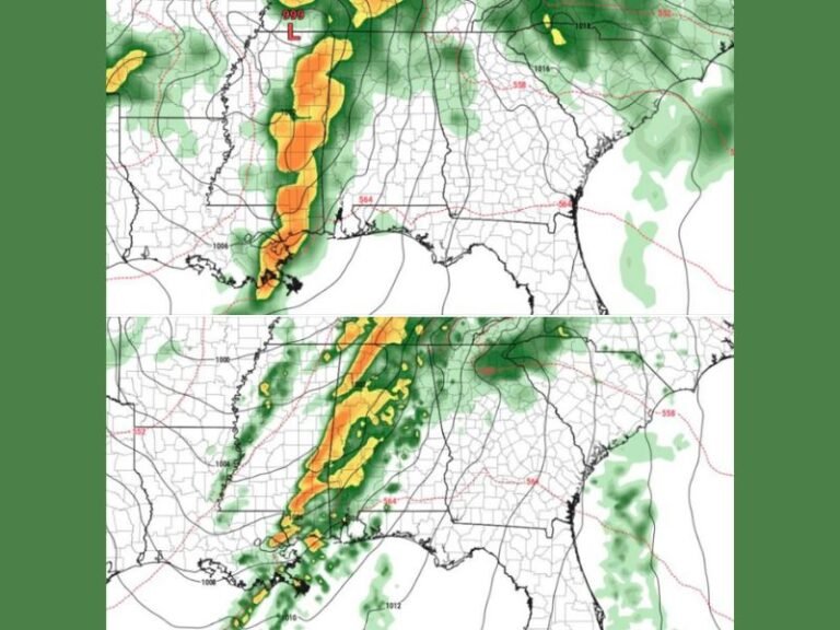
The atmospheric pattern change developing late this week will significantly amplify into the following week, driving a sustained and active severe weather regime across the central United States. The NIU Week 2 Supercell Composite Parameter model valid from May 20 through May 26, 2026 depicts the highest composite values concentrated across a broad zone centered over Illinois, Missouri, and surrounding states, with the most intense signal shown in green and yellow tones indicating elevated supercell thunderstorm potential across multiple days simultaneously.
Several significant severe weather days are considered likely across this corridor, making it one of the more notable extended severe weather setups of the 2026 spring season.
Illinois Missouri Indiana and Surrounding States Face Multi-Day Threat
The states most directly in the crosshairs of the developing pattern include Illinois, Missouri, Indiana, western Kentucky, Iowa, Arkansas, and Oklahoma, all of which fall within the elevated supercell composite zone depicted on the NIU model output. The multi-day nature of this threat distinguishes it from isolated single-event severe weather setups, reflecting a sustained and persistent atmospheric configuration capable of generating repeated tornado and severe thunderstorm opportunities across the affected states throughout the late May period.
Residents across all identified states are urged to begin monitoring forecasts closely as the active pattern approaches and specific severe weather timing becomes clearer through daily forecast updates.
Florida I-75 Corridor to See Daily PM Storms
The same pattern change driving Midwest severe weather will simultaneously produce a deep east to west flow across Florida, resulting in daily afternoon pop-up showers and storms along the I-75 corridor next week. Tampa, Sarasota, and Fort Myers are specifically identified as communities that will receive a boost of daily rainfall during this period, while central and eastern Florida communities will see comparatively less storm activity under the east to west flow regime through the late May timeframe.
For continuing coverage of severe weather events and critical storm analysis across the United States, visit SaludaStandard-Sentinel.com.