Isolated Mountain Thunderstorms Developing Across Tennessee and North Carolina Highlands Near Boone and Roan Mountain With Wildfire-Starting Lightning Risk
TENNESSEE AND NORTH CAROLINA — Isolated showers and thunderstorms developed across the higher mountain elevations at 8:33 PM Saturday, April 18, 2026, with radar showing active storm cells producing lightning near Boone, Roan Mountain, and Mountain City. Forecasters noted the primary concern with Saturday night’s storms is not rainfall amounts but rather lightning activity and its potential to ignite wildfires across the dry mountain terrain.
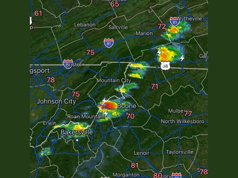
Temperatures across the region ranged from 70 degrees near Boone to 75 degrees in Johnson City and Bristol, with warmer readings of 77 to 81 degrees across lower elevation communities including North Wilkesboro and Morganton.
Storm Cells Producing Lightning Across Higher Elevations
Radar imagery showed two primary areas of active storm development Saturday evening. The most intense cell was positioned near Roan Mountain and Boone, where orange and red radar returns indicated heavier rainfall cores accompanied by multiple confirmed lightning strikes. A secondary storm area was developing further northeast near Wytheville and Marion along the Interstate 81 corridor.
The storms developed specifically across higher mountain elevations as daytime heating of elevated terrain triggered isolated evening thunderstorm development while surrounding lower elevation communities remained largely dry.
Wildfire Ignition Risk the Primary Concern
With dry conditions already in place across the mountain region and elevated wildfire danger ongoing, forecasters expressed specific concern about lightning potentially igniting new wildfire activity across the terrain. Lightning strikes on dry mountain slopes can start fires that spread rapidly given the combination of dry fuels, low humidity, and gusty terrain-driven winds common across the high elevations near Roan Mountain and Boone.
Fire weather monitoring was confirmed to be ongoing as the storm cells moved through, with forecasters watching closely to ensure any lightning-started ignitions were detected and reported to fire suppression crews quickly.
Limited Rainfall Expected From Isolated Storms
The isolated storms are capable of producing quick rain bursts beneath the most active cells, but rainfall totals are not expected to be significant enough to meaningfully address ongoing dryness across the mountain region. Residents spending time outdoors near Boone, Roan Mountain, and Mountain City should seek shelter immediately upon hearing thunder.
Did you see Saturday night’s mountain storms across Tennessee or North Carolina? Share your observations at SaludaStandard-Sentinel.com.