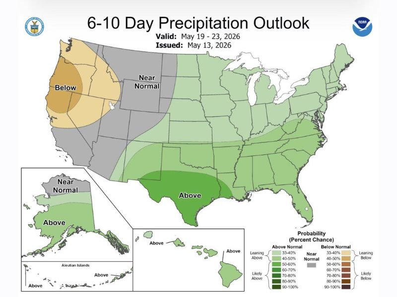
Above Normal Rainfall at 80 to 90 Percent Probability Targets Texas and the Eastern United States From May 19 to 23 as NOAA Six to Ten Day Outlook Signals Major Pattern Flip
SAN ANTONIO, TX — NOAA’s 6 to 10 Day Precipitation Outlook issued May 13, 2026 and valid May 19 through May 23 shows above normal rainfall probability across the entire eastern United States and Texas, with the highest confidence signal of 80 to 90 percent above normal precipitation concentrated directly over Texas as a significant pattern flip brings scattered rain chances returning as early as Monday across the region.
Texas Faces 80 to 90 Percent Above Normal Rainfall Probability
The most striking feature of the NOAA 6 to 10 Day Precipitation Outlook is the exceptionally high above-normal rainfall probability centered over Texas during the May 19 to 23 window. The dark green shading covering the state represents an 80 to 90 percent probability of above normal precipitation, one of the highest confidence signals on the entire national outlook map and reflecting strong meteorological agreement that Texas will receive significantly more rainfall than typical during this period.
Normal precipitation for San Antonio during the days covered by this outlook would be approximately 0.75 inches, meaning above normal totals are expected to exceed this baseline by a meaningful margin across the state.
Above Normal Signal Extends Across Entire Eastern United States
Beyond Texas, the above normal precipitation signal extends across a remarkably broad geographic footprint covering the entire eastern half of the United States from the Gulf Coast northward through the Great Plains, Midwest, and into the Northeast. The probability values across the eastern corridor range from 33 to 60 percent above normal, indicating a consistent and widespread wet pattern affecting millions of residents simultaneously during the late May period.
This broad coverage reflects the large-scale atmospheric pattern change driving increased moisture and storm activity across the eastern United States through the May 19 to 23 timeframe.
Below Normal Precipitation for Pacific Northwest and California
While the eastern United States faces above normal rainfall, the Pacific Northwest and California are forecast to experience below normal precipitation during the same May 19 to 23 period. The orange shading covering Washington, Oregon, and California on the outlook map reflects a 40 to 60 percent probability of below normal rainfall, continuing the drier pattern that has affected the West Coast region while the eastern states trend significantly wetter.
Scattered rain chances are expected to return to San Antonio and surrounding areas as early as Monday as the pattern flip begins establishing itself ahead of the full outlook period. For continuing coverage of severe weather events and critical storm analysis across the United States, visit SaludaStandard-Sentinel.com.