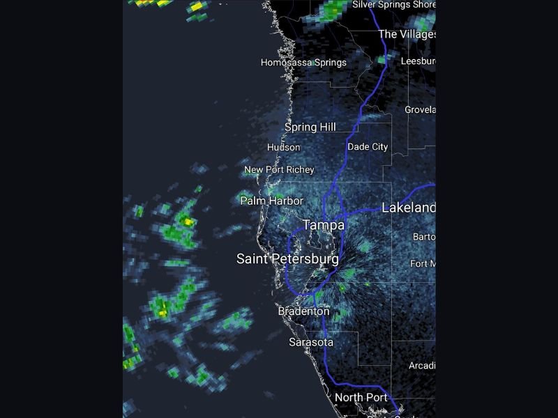
Rain Winding Down Across Tampa Bay and Gulf Coast Florida as Scattered Offshore Showers Diminish and Clearing Conditions Develop From Saint Petersburg Through Sarasota
TAMPA, FL — Rain is winding down across the Tampa Bay region and the broader Gulf Coast of Florida, with radar imagery showing diminishing shower activity over Tampa, Saint Petersburg, Bradenton, and Sarasota as scattered light precipitation pulls away from the coastline and clearing conditions begin developing across the region following the passage of the storm system.
Rain Diminishing Across the Tampa Bay Corridor
Radar imagery shows the bulk of the rainfall that impacted the Tampa Bay area has largely moved through, with remaining shower activity becoming increasingly scattered and light across the immediate coastal zone. The heaviest and most organized precipitation has cleared the primary population centers including Tampa, Saint Petersburg, and Bradenton, with only isolated and weakening returns remaining over portions of the region as the storm system exits to the east and southeast.
Communities including Spring Hill, New Port Richey, Palm Harbor, and Hudson along the northern Pinellas and Pasco County coastline are also seeing conditions gradually improve as the rainfall coverage contracts and weakens through the period.
Offshore Shower Activity Persisting Over Gulf Waters
While conditions are improving over land across the Tampa Bay metro area, radar imagery shows scattered shower activity continuing over the Gulf of Mexico waters to the west of the coastline. These offshore showers are moving generally away from the coast rather than onshore, supporting the improving trend across land-based communities from Homosassa Springs and Spring Hill southward through the Tampa Bay area and continuing toward Sarasota and North Port along the southwest Florida Gulf Coast.
The offshore nature of the remaining shower activity indicates the primary threat to coastal communities has largely passed for this particular weather event.
Gradual Clearing Expected Across Southwest Florida Coast
Conditions are expected to continue improving progressively from north to south across the southwest Florida Gulf Coast as the overall weather pattern shifts away from the active rainfall regime that impacted the region. Communities from The Villages and Leesburg through Lakeland, Bartow, and surrounding inland Polk and Highlands County areas are also tracking improving conditions as the broader storm system moves through and drier air begins to filter back across the Florida peninsula.
Residents across the Tampa Bay and southwest Florida Gulf Coast can expect continued gradual improvement through the remainder of the evening as the last of the shower activity clears the region.
For continuing coverage of severe weather events and critical storm analysis across the United States, visit SaludaStandard-Sentinel.com.