Persistent Storm Line Bringing 35 to 45 MPH Winds Lightning and Heavy Downpours Into Eastern Pennsylvania Wednesday Night as Line Tracks Toward Bethlehem Doylestown and Chester
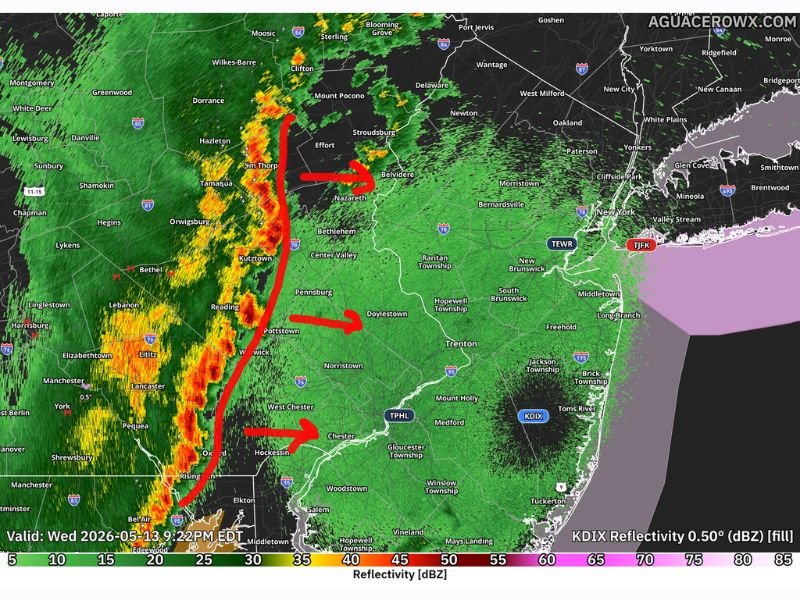
PHILADELPHIA, PA — A persistent line of storms refusing to dissipate is pushing into eastern Pennsylvania as of 9:22 PM EDT on Wednesday May 13, 2026, bringing wind gusts of 35 to 45 miles per hour, frequent lightning, and heavy downpours across the corridor from Tamaqua and Reading eastward toward Bethlehem, Doylestown, and Chester as the line advances toward the New Jersey border.
Storm Line Persists Despite Limited Instability
Despite limited atmospheric instability keeping the storm line below severe thresholds, the system has maintained organization and intensity as it pushes through the final portions of eastern Pennsylvania during the late evening hours. Radar imagery from KDIX at 9:22 PM shows a well-defined line of intense returns stretching from Hazleton and Tamaqua southward through Reading, Kutztown, Pottstown, and West Chester.
Three directional arrows on radar confirm the storm’s eastward track pointing toward Belvidere, Doylestown, and Chester as the line advances through the region.
Wind Gusts and Heavy Downpours the Primary Hazards
Wind gusts reaching 35 to 45 miles per hour represent the most significant hazard associated with this storm line across eastern Pennsylvania. While remaining sub-severe, gusts of this magnitude are still capable of downing small branches, scattering outdoor objects, and creating briefly dangerous driving conditions across communities in the storm’s direct path.
Frequent lightning and heavy downpours reducing roadway visibility are also expected throughout the Bethlehem, Allentown, Reading, and Philadelphia suburban corridor as the line pushes through during the late evening hours.
New Jersey Communities Next in the Storm’s Path
With the line advancing eastward through Pennsylvania’s final communities, New Jersey residents along the western border including Trenton, Princeton, and Burlington County should prepare for arriving storm activity as the system crosses the state line. The line is expected to gradually weaken as it encounters more stable atmospheric conditions away from its primary forcing zone overnight.
For continuing coverage of severe weather events and critical storm analysis across the United States, visit SaludaStandard-Sentinel.com.