High Storm Energy and Active Weather Pattern Return to Central Texas Next Week With Dryline to the West Fueling Cap-Dependent Storm Potential Across Austin San Antonio and Houston
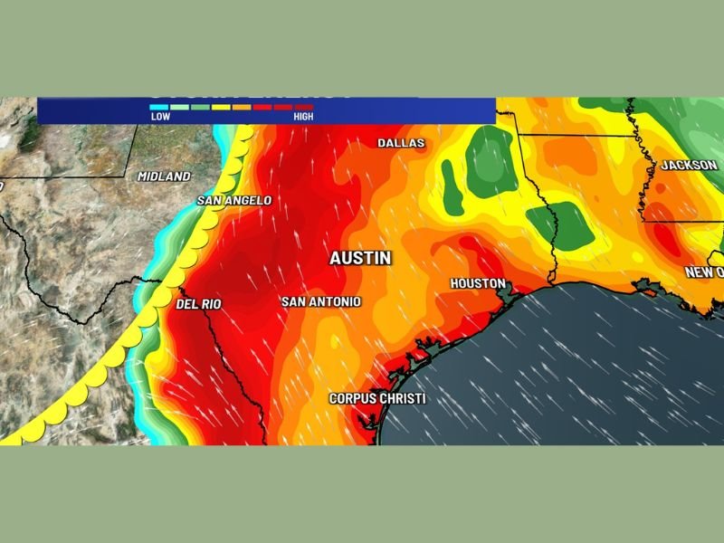
AUSTIN, TX — An active weather pattern is returning to Central Texas next week as a dryline positioned to the west brings a significant reservoir of storm energy back into the region, with KXAN First Warning Weather storm energy imagery valid for Monday at 2:00 PM showing extreme high energy values covering the Austin, San Antonio, Houston, and Dallas corridor as cap-dependent and conditional storm development becomes increasingly possible across the region.
High Storm Energy Builds Across Central Texas Monday
Storm energy analysis imagery for Monday 2:00 PM depicts an intense and expansive zone of high atmospheric energy blanketing Central Texas from the Dallas area southward through Austin, San Antonio, and Corpus Christi and extending eastward toward Houston. The deep red returns on the storm energy map represent the highest available energy tier, indicating that abundant instability and moisture will be in place across the region to support significant thunderstorm development if the atmospheric cap breaks during the afternoon heating hours.
The dryline positioned to the west of Central Texas serves as the primary triggering boundary where storm initiation is most likely once sufficient surface heating overcomes any capping inversion present in the atmosphere.
Cap-Dependent and Conditional Storm Setup
The storm potential for next week across Central Texas is described as cap-dependent and conditional, meaning that storm development is not guaranteed but rather contingent on whether afternoon heating is sufficient to break through the atmospheric cap that suppresses convection during the daytime hours. When the cap does break in this type of setup, storms that initiate can rapidly become intense due to the large reservoir of available storm energy depicted across the Central Texas corridor.
This type of conditional setup requires close monitoring as the forecast period approaches, since the difference between a quiet afternoon and an explosive storm outbreak can hinge on relatively subtle atmospheric details that become clearer only in the days immediately preceding the event.
Too Early for Specific Severe Risks But Worth Watching
Forecasters note that the timeframe is currently too far out to outline specific severe weather risks or identify precise storm corridors across Central Texas for next week’s active pattern. However, the combination of a well-positioned dryline, abundant storm energy, and an active overall atmospheric pattern makes this a setup worthy of continued close monitoring through the coming days as model guidance refines the details of storm timing, coverage, and intensity potential across the region.
For continuing coverage of severe weather events and critical storm analysis across the United States, visit SaludaStandard-Sentinel.com.