Over a Foot of Snow Hits Colorado Foothills With Heavy Rain Along I-25 Corridor South of Denver Into El Paso County as Complex Storm System Continues 12 to 18 More Hours
DENVER, CO — A complex and multi-faceted storm system delivered dramatically different precipitation outcomes across Colorado, dropping over a foot of snow across the foothills while the I-25 corridor south of Denver into El Paso County received well over an inch of rain, as an active radar picture confirmed the system was set to continue impacting the state for an additional 12 to 18 hours.
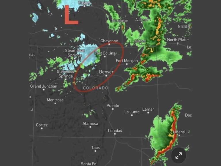
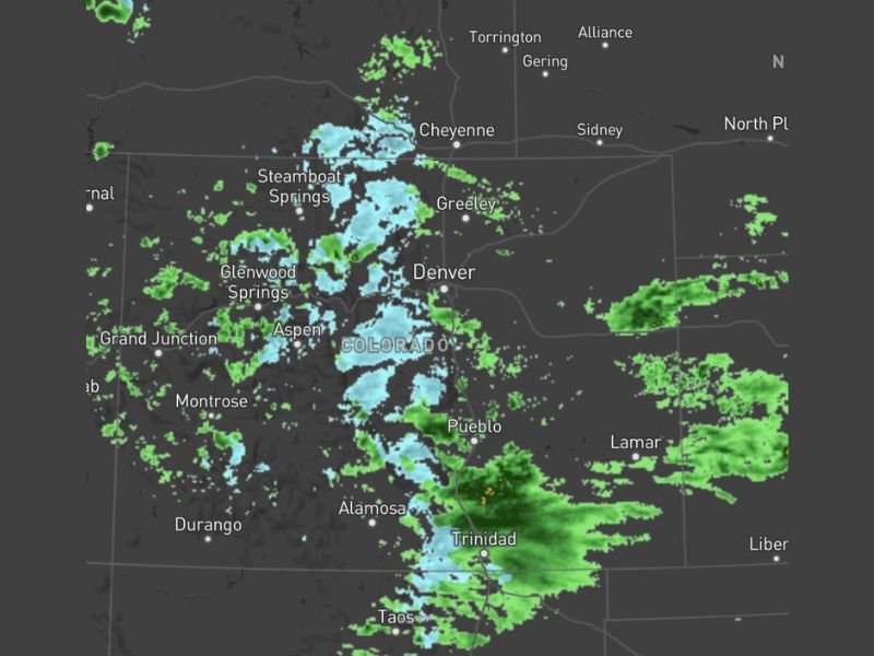
Radar imagery showed widespread precipitation coverage blanketing the full Colorado Front Range and mountain corridor, with light blue snow signatures concentrated across the central mountains stretching from Steamboat Springs and Glenwood Springs through Aspen, Denver, and southward toward Pueblo, Alamosa, and Trinidad, while green rain returns dominated the eastern plains and southern portions of the state.
Foothills Receive Over a Foot of Snow
The most dramatic precipitation outcome from the storm system was concentrated across the Colorado foothills, where accumulations exceeded one foot of snow during the event. The foothills terrain, positioned along the eastern slopes of the Rockies, captured the heaviest snowfall from the system as moisture-laden upslope flow maximized precipitation across the elevated terrain between the plains and the high mountain peaks.
The substantial snow accumulations across the foothills represented a significant late-season snowfall event for Colorado, with radar confirming continued snow coverage across the mountain and foothill zones as the system maintained its intensity through the ongoing precipitation period.
I-25 Corridor South of Denver Sees Heavy Rain
While the foothills collected deep snow, the I-25 corridor south of Denver running into El Paso County experienced a very different precipitation type, with well over an inch of rain accumulating across that stretch of the Front Range. The rain versus snow line across Colorado reflected the complex interplay of elevation, temperature, and dry air entrainment that made this storm system particularly challenging to forecast with precision across different zones of the state.
Dry air entrainment across northern Colorado contributed to some areas reporting precipitation on radar that was evaporating before reaching the ground, a phenomenon known as virga that further complicated the precipitation picture across the region during the event.
System to Continue for 12 to 18 More Hours
With radar showing significant ongoing precipitation coverage across the full state from Steamboat Springs and Greeley in the north through Trinidad and Taos in the south, the storm system was expected to continue impacting Colorado for an additional 12 to 18 hours before gradually winding down. The extended duration of the event meant additional snow accumulations across the foothills and mountains and continued rainfall across the southern and eastern portions of the state through the remainder of the precipitation period.
Residents across Denver, Pueblo, Colorado Springs, Alamosa, Trinidad, and surrounding communities were advised to monitor updated forecasts through the ongoing event as conditions continued to evolve across the complex Colorado storm system.
For continuing coverage of weather events and critical storm analysis across the United States, visit SaludaStandard-Sentinel.com.