Possible Landspout and Stunning Storm Structure Documented Across the Desolate Open Terrain of Southwest Texas in a Rare and Visually Spectacular Chase Day
SOUTHWEST TEXAS — A visually spectacular and atmospherically unique storm chase unfolded across the wide open desolate terrain of southwest Texas, producing a possible landspout and extraordinary storm structure photography against a dramatic backdrop of desert landscape, mountain scenery, and striking storm coloration.
The chase, described as a much needed change of pace from the high intensity outbreak events that have dominated the current severe weather season, offered a rare opportunity to observe and document a gorgeous and photogenic storm system in one of the most remote and scenically dramatic environments in the continental United States.
Possible Landspout Documented Against Dramatic Desert Mountain Backdrop in Southwest Texas
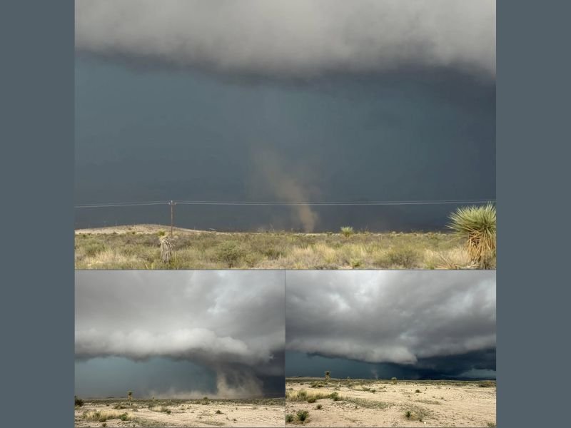
The highlight of the southwest Texas chase was the documentation of a possible landspout spinning up beneath the storm base against the stark white and tan desert ground and distant mountain backdrop. Landspouts are tornado-like circulations that develop through a different mechanism than supercell tornadoes, forming from the ground upward as a pre-existing boundary layer vortex is stretched and intensified by a developing storm updraft rather than from a rotating mesocyclone descending from above.
Photographic documentation of the possible landspout shows a narrow and dust filled circulation visible at the surface beneath the storm’s dark base, with the surrounding desert scrub and yucca vegetation of southwest Texas providing a distinctive and dramatic visual foreground for the observed atmospheric phenomenon.
Storm Structure Displays Striking Color Combination Across Remote Southwest Texas Landscape
The storm system observed across southwest Texas displayed an unusually striking visual character, with greens, blues, and greys within the storm structure contrasting dramatically against the white and tan desert ground and the distant mountain backdrop. The combination of storm coloration, terrain, and lighting produced photography of exceptional visual quality, with storm observers documenting the scene from a safe distance due to the overall lack of road access across the remote southwest Texas landscape.
The absence of the dense road network typical of Great Plains chase environments forced a more observational approach to the storm documentation, resulting in a calmer and more reflective chase experience compared to the rapid repositioning demands of more intense outbreak scenarios.
Southwest Texas Chase Sets the Stage for Another Potentially Active Day to the North
Following the southwest Texas chase, attention shifts northward where similar or potentially more intense storm chase opportunities are anticipated the following day. The northward repositioning following the southwest Texas event reflects the ongoing and active severe weather pattern across a broad portion of the central United States as the late spring storm season continues to generate significant chase opportunities across multiple regions simultaneously.
For continuing coverage of storm chase events and severe weather documentation across the United States, visit SaludaStandard-Sentinel.com.