Flash Flooding Reported Near Georgetown and Round Rock as Periods of Light Rain Sweep Across San Antonio, Austin and Surrounding Texas Communities Tuesday Morning
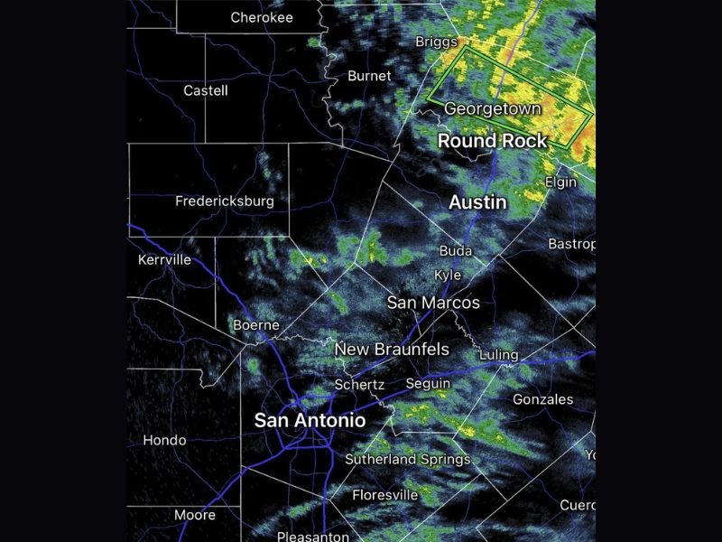
CENTRAL TEXAS — Periods of light rain are moving across a broad stretch of Central Texas on Tuesday morning, April 21, 2026, bringing soggy and overcast conditions to communities stretching from San Antonio northward through Austin and into the Georgetown and Round Rock corridor. While much of the region is experiencing light and steady rainfall, flash flooding has been reported ongoing in the Georgetown and Round Rock area as of 11:20 AM, where radar is showing the heaviest and most concentrated precipitation of the entire event.
The radar imagery captured at 11:19 AM shows intense returns in yellow and orange tones centered over Georgetown and Round Rock, indicating significantly heavier rainfall in that corridor compared to the lighter, more scattered activity further south across the San Antonio metro and surrounding Hill Country communities.
Flash Flooding Ongoing Near Georgetown and Round Rock
The most urgent weather concern Tuesday morning is the ongoing flash flooding in and around Georgetown and Round Rock, located just north of Austin. Radar is indicating heavy and persistent rainfall over this corridor, and forecasters are tracking the situation closely as water levels in low-lying areas and roadways may be rising rapidly. Residents in Georgetown, Round Rock, and nearby Elgin are being urged to avoid any flooded roadways and to never attempt to drive through standing or moving water, regardless of how shallow it may appear.
Flash flooding can develop quickly and without warning in urban areas, particularly when heavy rainfall occurs over a short period. Anyone in the affected zone should monitor local emergency alerts and move to higher ground if necessary.
Light Rain Spreads Across Austin and the San Antonio Metro
While the flash flooding threat is concentrated to the north, the broader Austin and San Antonio metropolitan areas are experiencing periods of light rain throughout Tuesday morning. Austin, Buda, Kyle, San Marcos, and New Braunfels are all seeing steady light precipitation moving through the region, contributing to wet road conditions and reduced visibility in some areas.
In the San Antonio metro, communities including Schertz, Seguin, Boerne, and Floresville are all under the same general rain shield, with conditions described as soupy and overcast. Drivers across the region are advised to slow down, increase following distances, and use headlights during periods of reduced visibility.
Hill Country and Southern Communities Also Seeing Rain
Further west and south, the rain shield extends into the Hill Country and communities well south of San Antonio. Fredericksburg, Kerrville, and Hondo are all seeing light precipitation, while Pleasanton, Campbellton, Karnes City, and Beeville further south are also within the rain area as the system continues to push through the region.
Pawnee, Calliham, and Berclair in the southern portion of the radar coverage area are also picking up light rainfall, indicating the widespread nature of the precipitation event across a large portion of South and Central Texas.
Are you experiencing the rain or flooding conditions across Central Texas today? Share what conditions look like in your community and stay informed with the latest weather coverage at SaludaStandard-Sentinel.com.