Strong to Severe Thunderstorms With Damaging Winds Threatening All of Pennsylvania Thursday as Heat Index Values Reach the Low 100s and Highs Climb to 97 Degrees
HARRISBURG, PA — A dangerous combination of extreme heat and strong to severe thunderstorm potential is unfolding across all of Pennsylvania on Thursday, June 11, with afternoon high temperatures climbing into the mid-80s to upper 90s statewide, heat index values reaching the mid-90s to low 100s, and damaging wind-producing thunderstorms becoming increasingly likely through the afternoon and evening hours.
Statewide Heat Thursday Afternoon
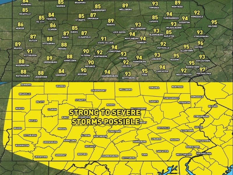
PA Weather Plus afternoon high temperature data shows a dramatic east-west temperature gradient across Pennsylvania Thursday. Eastern communities will bear the most extreme heat, with Philadelphia topping out at 97°F, Norristown reaching 95°F, Allentown and Easton both hitting 95 to 96°F, and the Harrisburg corridor including York, Lancaster, and Chambersburg climbing to 93 to 95°F.
Central Pennsylvania also faces intense heat, with State College at 91°F, Lewistown at 92°F, and Mifflinburg reaching 94°F. Western communities including Pittsburgh will reach 91°F, with Butler at 87°F and Erie staying relatively cooler in the mid-80s along the Lake Erie shoreline.
Heat Index Warning
The combination of mid-80s to upper-90s temperatures with elevated humidity levels will push heat index values into the mid-90s to low 100s across much of the state Thursday afternoon. Residents spending extended time outdoors should take prolonged breaks from direct sun exposure, stay consistently hydrated, and limit strenuous physical activity during the 1 to 6 p.m. peak heating window.
Severe Weather Potential Thursday Afternoon and Evening
The same heat and humidity fueling dangerous heat index values will simultaneously provide enormous instability for thunderstorm development through the afternoon and evening. A severe weather potential map updated at 5:30 a.m. June 11 covers the entire state of Pennsylvania in a strong to severe storm zone, with damaging wind gusts identified as the primary hazard for any storms that develop.
Strong to severe thunderstorms are increasingly likely statewide during the afternoon and evening hours, with the storm threat persisting well into the night across eastern Pennsylvania.
Staying Safe Thursday
Pennsylvania residents should keep weather alert systems active on all devices throughout Thursday afternoon and evening. Complete outdoor activities before early afternoon where possible and have an interior shelter plan ready before storms arrive.
For continuing coverage of Pennsylvania heat and severe weather threats across the United States, visit SaludaStandard-Sentinel.com.