Intense Squall Line With Tornado Warnings Sweeping Across Missouri and Illinois Targeting Chicago and St. Louis Friday
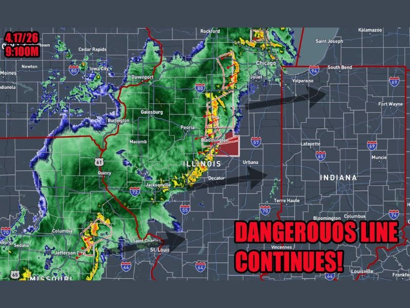
MISSOURI AND ILLINOIS — An intense squall line loaded with numerous embedded circulations and active tornado warnings was sweeping northeast across Missouri and Illinois at 9:10 PM Friday, April 17, 2026, with forecasters warning that Chicago and St. Louis are both directly in the storm’s path and expected to be impacted within the next one to two hours. The dangerous line is expected to continue producing severe weather for at least another two to three hours before conditions finally clear for the night.
Radar imagery captured at 9:10 PM showed the squall line stretching across a massive corridor from St. Louis northward through Bloomington, Peoria, and toward Chicago, with multiple active tornado warning boxes visible along the line as it pushed aggressively northeast.
Chicago and St. Louis Directly in the Storm’s Path
Both of Illinois’ largest population centers are squarely in the path of Friday night’s dangerous squall line. Chicago and surrounding suburbs including Joliet, Rockford, and Valparaiso are expected to feel the full brunt of the line within the next hour or two from the time of the 9:10 PM update. Simultaneously, St. Louis and surrounding communities including Saint Charles and Jefferson City in Missouri are also being impacted as the southern end of the squall line sweeps through.
Residents in both metro areas were urged to have weather radios on and remain in shelter until the line fully passes their location, as embedded tornado circulations can produce brief but violent tornadoes with minimal warning time even within a squall line environment.
Tornado Warnings Active Along the Line
Multiple active tornado warning polygons were visible on radar along the squall line as of the 9:10 PM update, concentrated primarily across central Illinois near Bloomington, Peoria, and Urbana as the most intense portion of the line tracked northeast. The warning boxes indicated that radar-confirmed or radar-indicated tornado circulations were present within the squall line at multiple points simultaneously.
Communities including Decatur, Champaign, Urbana, and surrounding central Illinois areas were under the most immediate tornado threat as the line pushed through during the late evening hours.
Radios On Until the Line Passes
Forecasters issued a clear and urgent message for all residents across the affected corridor — keep weather radios on until the squall line fully passes your location. Once the line moves through, conditions are expected to improve rapidly and the severe weather threat will end for the night across each area as the system tracks northeast.
Residents should remain in interior shelter locations away from windows until local forecasters confirm the line has cleared their specific area completely.
Were you impacted by Friday night’s squall line across Missouri or Illinois? Share your experience and stay connected at SaludaStandard-Sentinel.com.