High Ceiling Severe Weather and Increasing Tornado Threat Forecast Across Nebraska and Kansas Both Saturday and Sunday Evening This Weekend
OMAHA, NE — A significant and potentially dangerous severe weather setup is developing across Nebraska and Kansas this weekend, with NAM model forecast data depicting a high ceiling severe weather environment and an increasing tornado threat during the evening hours on both Saturday and Sunday as upper level troughs interact with low level easterly winds and substantial atmospheric instability across the central plains.
Saturday Evening Setup and EHI Values
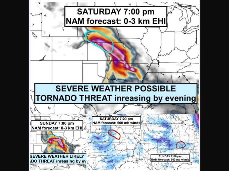
NAM forecast data valid for Saturday at 7:00 PM shows a striking and highly concentrated axis of elevated Energy Helicity Index values in the zero to three kilometer layer stretching across a focused corridor through Nebraska and into Kansas, with the deepest and most intense values depicted in purple and deep orange shading indicating an atmospheric environment strongly supportive of supercell thunderstorm development and tornado production during the evening hours.
The 0-3 km EHI is one of the most reliable composite parameters for identifying areas where rotating supercell thunderstorms capable of producing significant tornadoes are most likely to develop, and Saturday evening’s values across the highlighted Nebraska corridor are sufficiently elevated to warrant serious attention from residents and emergency managers across the region.
Sunday Threat Continues and Intensifies
Rather than a single day event, this weekend severe weather setup extends into Sunday evening with NAM forecast data valid for Sunday at 7:00 PM showing a continued and potentially more focused EHI axis shifting southward across the Nebraska and Kansas border region.
Sunday’s setup is characterized by forecasters as an environment where severe weather is likely rather than merely possible, with the tornado threat again increasing as evening approaches and low level wind shear tightens in conjunction with the upper level trough position depicted in the 500 millibar wind analysis for both days of the weekend event.
Why Upper Level Troughs Still Matter in Late May
Upper level troughs during late May can appear relatively weak on standard atmospheric analysis charts, but their interaction with strong low level easterly winds and significant instability during peak heating hours creates a deceptively dangerous severe weather environment that should not be underestimated based solely on the appearance of the upper level pattern.
The combination of modest upper flow with abundant low level shear and instability is precisely the recipe that has historically produced significant tornado outbreaks across the central plains during the late May period.
Residents Should Have a Weekend Weather Plan
Communities across Nebraska and Kansas are urged to enter this weekend with a clear severe weather action plan, ensure access to reliable weather alert systems, and monitor updated forecasts closely as Saturday and Sunday evening approaches and storm initiation becomes imminent across the region. For continuing coverage of tornado threats and severe weather outbreaks across the United States, visit SaludaStandard-Sentinel.com.