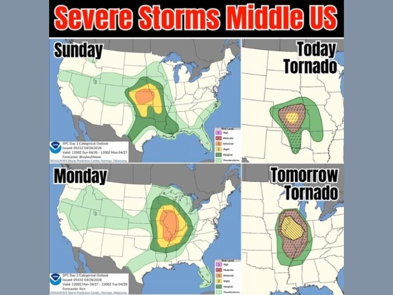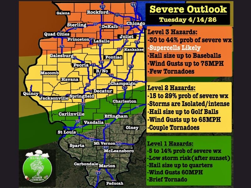
Illinois Severe Threat Upgraded to Level 3 Tuesday With Baseball-Sized Hail, 75 MPH Winds and Tornadoes Targeting Chicago, Rockford and Northern Illinois from 5 PM to 10 PM
ILLINOIS — The Storm Prediction Center has upgraded northern Illinois to a Level 3 Enhanced severe weather risk for Tuesday April 14, 2026, with dangerous supercells expected to fire between 5 PM and 10 PM carrying baseball-sized hail, wind gusts up to 75 MPH, and a tornado threat for communities including Chicago, Rockford, DeKalb, Joliet, and Kankakee. This is a significant and potentially life-threatening severe weather upgrade that every Illinois resident must take seriously before Tuesday afternoon arrives.
Level 3 Zone Faces Supercells With All Hazards Between 5 PM and 10 PM
The Level 3 Enhanced risk covers northern Illinois and carries a 30 to 44 percent probability of severe weather. Early morning storms between 1 AM and 7 AM will bring gusty winds with very low tornado risk before clearing after sunrise.
After 6 PM the atmospheric cap begins breaking and supercells are expected to bubble up rapidly. These storms will carry all hazards including giant hail up to baseball size, wind gusts reaching 75 MPH, and a few tornadoes. Storm coverage is forecast at 40 to 50 percent, meaning many areas will stay dry but those that see storms could face significant and dangerous impacts.
Level 2 Zone Watching for Intense Isolated Storms After 4 PM
The Level 2 Slight risk zone covering central Illinois including Peoria, Bloomington, Champaign, Decatur, Springfield, and Charleston faces a 15 to 29 percent probability of severe weather. A strong cap will prevent widespread storm coverage, keeping storm probability at just 10 to 20 percent.
However any storm that breaks through the cap will be intense and dangerous. Golf ball-sized hail, wind gusts to 65 MPH, and a couple of tornadoes are all possible within the Level 2 zone. Weaker storms moving in after 10 PM from the west are also expected across this region.
Level 1 Zone Covers Southern Illinois With Brief Tornado Risk
Southern Illinois communities including Carbondale, Marion, McLeansboro, and Mt. Vernon fall under the Level 1 Isolated risk with a 5 to 14 percent probability of severe weather. Hail up to quarter size, wind gusts to 60 MPH, and a brief tornado are possible mainly between 5 PM and 10 PM before storm activity weakens after sunset.
While the Level 1 threat is lower, residents across southern Illinois should not dismiss it entirely as isolated intense storms can still produce dangerous conditions with little warning.
Every Illinois resident from Chicago to Carbondale must have weather alerts active and shelter plans ready before Tuesday afternoon. Stay weather aware at SaludaStandard-Sentinel.com.