Cold Front Sweeps Southeast With Storm Line and Over 2 Inches of Rainfall Across Georgia, Atlanta, Nashville, and Jackson Wednesday Night Into Thursday Morning
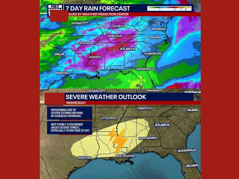
ATLANTA, GA — A cold front was forecast to sweep across the Southeast United States on Wednesday night into Thursday morning, bringing a weakening line of storms and over 2 inches of rainfall across many spots throughout Georgia, Tennessee, and the broader Southeast corridor as the Storm Prediction Center outlined a severe weather area for Wednesday afternoon and evening west of the region.
The 7-day rain forecast issued by the Weather Prediction Center showed deep purple and magenta rainfall totals concentrated across a broad area stretching from Little Rock and Jackson through Nashville and Atlanta, with accumulations exceeding 3 inches across the heaviest zones and meaningful rainfall extending eastward through Charleston and toward the Carolinas through the 7-day period.
Severe Threat Remains Low for Northern Georgia
While the cold front carried a severe weather risk west of the region, the setup was not considered overly concerning for northern Georgia, particularly given the early morning timing of the storm line arrival on Thursday. The modeling had consistently placed the line pushing through during the early morning hours, when reduced instability and the overnight timing worked against significant severe weather development across the northern Georgia corridor.
A weakening line of severe storms moving in Thursday morning was the primary storm mode expected, with the severe threat concentrated further west across the Mississippi and Louisiana corridor ahead of the frontal passage.
Over 2 Inches of Rainfall Provides Drought Relief
The most welcomed aspect of the Wednesday night into Thursday system was the rainfall potential, with totals exceeding 2 inches forecast across many spots throughout the region over the 7-day period. The substantial precipitation accumulation represented another meaningful step toward drought recovery across Georgia and surrounding Southeast states that had been dealing with dry conditions through the spring season.
Additional shower chances next weekend were expected to contribute to the overall 7-day totals, pushing cumulative rainfall even higher across drought-affected communities throughout the region.
For continuing coverage of weather events and critical storm analysis across the United States, visit SaludaStandard-Sentinel.com.