Noisy Storms With Frequent Lightning Drop Beneficial Rainfall Across Texas Hill Country Friday Night With Northwest Bexar County and San Antonio Metro Expected Within 30 to 45 Minutes
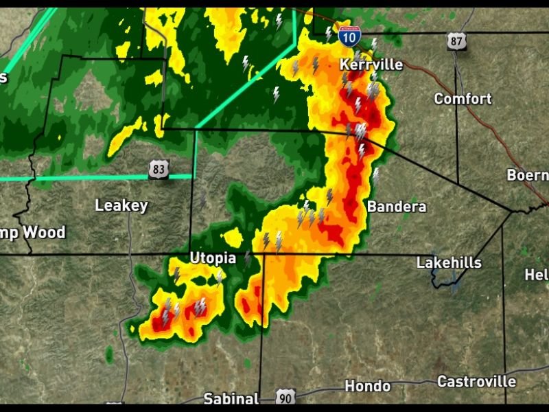
SAN ANTONIO, TX — A line of noisy but non-severe storms packed with frequent lightning and beneficial rainfall is moving east-southeast through the Texas Hill Country at 10:15 PM Friday, dropping welcome rain across river watersheds as it progresses toward the San Antonio metropolitan area. Live Power Doppler radar captured at 10:10 PM shows the storm complex concentrated along a corridor stretching from Kerrville southward through Bandera and Utopia, with the leading edge expected to reach northwest Bexar County within the next 30 to 45 minutes.
Active Storm Line Tracks East Southeast From Kerrville Through Bandera and Utopia
The storm complex visible on Live Power Doppler at 10:10 PM shows red and orange reflectivity returns concentrated along the Kerrville, Bandera, and Utopia corridor, with intense and frequent lightning signatures scattered throughout the active line as it moves east-southeast across the Hill Country terrain. Despite the noisy and visually active appearance on radar, forecasters have characterized the system as non-severe, with the primary hazards being frequent lightning and heavy rainfall rather than damaging winds or large hail.
The storm line extends southward from the Interstate 10 corridor near Kerrville through Bandera County and into the Utopia area, with all communities along this corridor currently experiencing the heaviest rainfall and most active lightning within the system.
Beneficial Rainfall Dropping Across Hill Country River Watersheds
One of the most positive aspects of Friday night’s storm activity is the beneficial rainfall being deposited across river watersheds throughout the Hill Country region as the line moves east-southeast. These watersheds feed several major river systems supplying water to communities across central and south Texas, making this rainfall valuable for water supply replenishment and drought mitigation across the broader region.
The non-severe nature of this system combined with its meaningful rainfall contribution makes Friday night’s storm passage a generally welcome weather event for the Hill Country despite the frequent lightning and noisy character of the activity.
Northwest Bexar County Faces Storm Arrival Within 30 to 45 Minutes
The east-southeast track places northwest Bexar County within the storm’s expected arrival zone within 30 to 45 minutes from the 10:15 PM observation. Residents across northwest Bexar County, Boerne, Helotes, and Timberwood Park should expect the arrival of rainfall and frequent lightning as the non-severe storm line completes its movement through the region during the late evening hours, with conditions improving as the system pushes further southeast through the overnight period.
For continuing coverage of storm tracking and rainfall updates across the United States, visit SaludaStandard-Sentinel.com.