Severe Storms With 60 MPH Wind History and Quarter Size Hail Marching Through Western Nebraska From Scottsbluff to Potter and Sidney Friday Evening
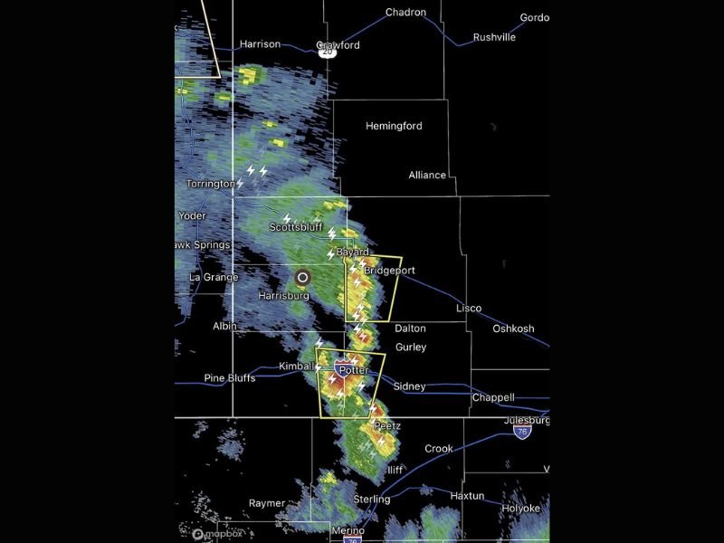
SCOTTSBLUFF, NE — A dangerous line of severe thunderstorms carrying a confirmed history of 60 mile per hour wind gusts and quarter size hail is marching southward through western Nebraska Friday evening, with radar imagery showing an intense and elongated storm corridor stretching from the Harrison and Torrington area southward through Scottsbluff, Bayard, Bridgeport, Harrisburg, Kimball, Potter, Sidney, and Peetz as active warning polygons encompass the most dangerous storm cores along the line.
Intense Storm Line Spans Western Nebraska
Radar reflectivity imagery shows a well-defined and continuous line of severe thunderstorm activity extending across a lengthy north to south corridor through the western Nebraska panhandle, with the storm system displaying deep yellow, orange, and red reflectivity values indicating extremely heavy precipitation and intense storm dynamics concentrated within multiple active cells along the advancing line.
The elongated nature of the storm complex means that communities across a wide swath of the Nebraska panhandle from the Wyoming border region southward toward the Colorado state line are all experiencing or facing imminent severe weather impacts as the system continues its southward progression through the Friday evening hours.
Warning Polygons Target Bridgeport and Potter Corridors
Active severe thunderstorm warning polygons visible on radar imagery are specifically concentrated across two primary areas of concern along the storm line, with one warning box encompassing the Bridgeport and Bayard corridor in Morrill County and a second warning polygon targeting the Kimball, Potter, and Sidney area in Kimball and Cheyenne counties.
These warning boundaries reflect the locations of the most organized and intense storm cores within the broader severe weather line, where 60 mile per hour wind gusts and quarter size hail represent verified or radar-confirmed threats to communities within the polygon boundaries during the active warning period.
Lightning and Multi-Hazard Threat
Frequent and intense lightning strikes are clearly visible throughout the storm line on radar imagery, with multiple lightning indicators scattered across the full length of the severe weather corridor from Torrington and Scottsbluff southward through Kimball and into the Peetz and Sterling areas crossing toward northeastern Colorado.
The combination of damaging winds, quarter size hail, heavy rainfall, and prolific lightning activity makes this a genuine multi-hazard severe weather event requiring immediate protective action from all residents across the affected Nebraska panhandle communities.
Residents Must Take Immediate Shelter
All residents across Scottsbluff, Bayard, Bridgeport, Harrisburg, Kimball, Potter, Sidney, and surrounding western Nebraska panhandle communities are urged to move indoors immediately, stay away from windows, and avoid all outdoor exposure until the severe storm line clears the area and conditions improve.
For continuing coverage of severe thunderstorm events and Nebraska storm impacts across the United States, visit SaludaStandard-Sentinel.com.