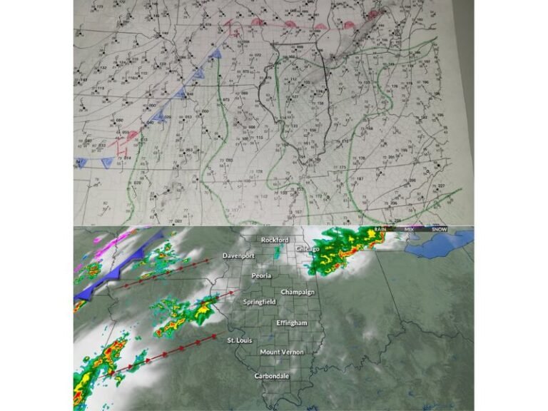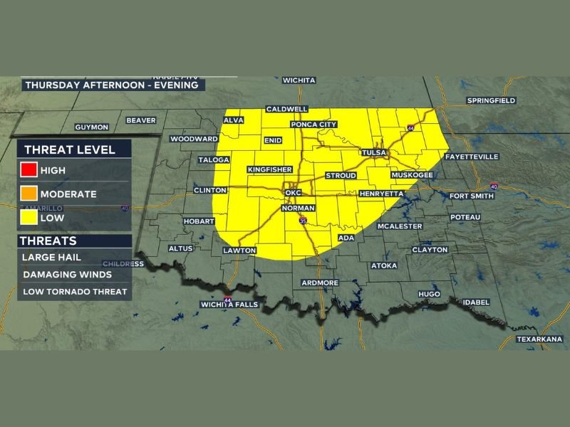
Severe Storms to Strike Oklahoma Thursday Afternoon and Evening, Large Hail, Damaging Winds and Tornado Threat Possible Across Tulsa, OKC and Surrounding Areas
OKLAHOMA — After a few days of quiet and calm conditions, Oklahoma is preparing for its next round of severe weather arriving Thursday afternoon and evening. Forecasters warn that the storm system could bring a combination of large hail, damaging winds, and a low tornado threat across a wide stretch of central and eastern Oklahoma before the system moves out. The current outlook suggests this will be a one-day event, unless the system slows down unexpectedly.
The threat zone highlighted for Thursday afternoon into the evening covers a significant portion of the state, stretching from Enid and Ponca City in the north down through Oklahoma City, Norman, and Lawton in the south, and extending eastward through Tulsa, Muskogee, and McAlester.
What Threats Are Expected Thursday
The Storm Zone threat map places the affected area under a Low threat level for Thursday, which still carries meaningful risks for residents in the zone. The primary concerns include large hail capable of damaging vehicles and property, damaging winds that could bring down trees and power lines, and a low but real tornado threat that should not be dismissed. While conditions are not expected to reach High or Moderate threat levels, a Low designation across such a wide area means a large number of Oklahomans need to remain weather-aware through the afternoon and evening hours.
Cities and Communities in the Threat Zone
The threat zone covers some of Oklahoma’s most populated corridors. Communities including Oklahoma City, Norman, Tulsa, Enid, Ponca City, Kingfisher, Stroud, Henryetta, Muskogee, Ada, Ardmore, Lawton, and Altus all fall within the outlined risk area. Residents across central and eastern Oklahoma should monitor local forecasts closely as Thursday approaches, particularly during the afternoon hours when storm development is most likely to begin.
How to Stay Prepared Ahead of Thursday
With quiet weather expected in the days leading up to Thursday, residents have time to prepare now. Securing outdoor furniture, checking emergency weather alerts on phones, and identifying a safe shelter location indoors are all recommended steps. Anyone with travel plans through central or eastern Oklahoma on Thursday should build extra time into their schedule and avoid driving through active storm areas. Forecasters note the system should move through in a single day, but the timeline could shift if the storm slows down.
Have you experienced severe weather in Oklahoma this season? Share your story and stay informed at SaludaStandard-Sentinel.com.