Widespread Storms and Low Tornado Risk Return to Arkansas on Thursday With Rain and Thunderstorms Forecast to Continue Statewide Through the Day
LITTLE ROCK, AR — Arkansas is set to see another active storm day on Thursday as rain and thunderstorm chances continue statewide, mirroring conditions observed Wednesday when beneficial rainfall and scattered thunderstorms moved through much of the state throughout the day.
Thursday Pattern Mirrors Wednesday Activity
The Thursday forecast carries a very similar setup to what Arkansas residents experienced Wednesday, with continued rounds of rain and storms expected to develop and progress through the day across a broad geographic area of the state.
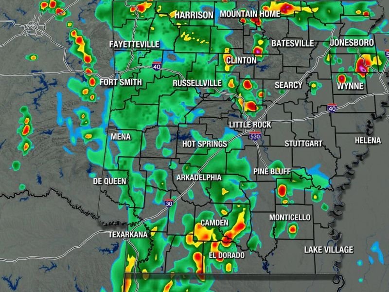
Futurecast imagery valid for Thursday at 6 PM shows widespread green and yellow radar returns blanketing nearly the entire state, with pockets of heavier activity indicated by orange and red returns concentrated across western, central, and southern Arkansas including areas near Fort Smith, Russellville, Hot Springs, Camden, and El Dorado.
Low Tornado Risk Present but Not Zero
Forecasters note that a low tornado risk exists for Thursday, consistent with the marginal severe weather environment observed during Wednesday’s storm activity across the state.
While the tornado threat is not expected to be significant and major impacts are not anticipated, the risk does remain above zero, meaning isolated storm cells could briefly produce rotating conditions at any point during the day. Residents are advised to remain aware of changing conditions and keep weather alerts active throughout Thursday.
Communities Across Arkansas in the Forecast Zone
The futurecast radar depiction shows storm coverage extending from the northwest Arkansas corridor near Fayetteville and Harrison southward through Little Rock, Pine Bluff, Monticello, and into the El Dorado and Texarkana areas in the south.
Eastern Arkansas communities including Jonesboro, Wynne, Batesville, and Helena also fall within the broader precipitation shield, indicating that few areas of the state will entirely escape the influence of Thursday’s unsettled weather pattern as storms progress through the afternoon and evening hours.
Staying Informed Through the Day
Given the continuity of storm activity from Wednesday into Thursday, residents throughout Arkansas are encouraged to monitor updated forecasts regularly as storm timing and intensity may shift during the active period.
Conditions are expected to gradually improve as the system progresses, but awareness and preparedness remain important throughout the full duration of Thursday’s weather window. For continuing coverage of severe weather events and storm forecasts across the United States, visit SaludaStandard-Sentinel.com.