Supercell Triggers Massive Haboob Near Goodland Kansas as 80 MPH Damaging Winds Kick Up Walls of Dust Across the High Plains
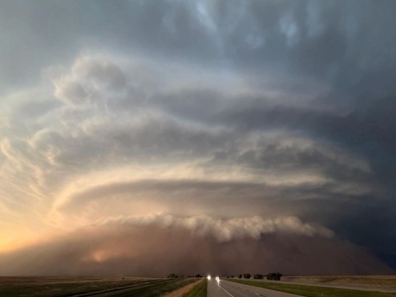
GOODLAND, KS — A powerful supercell thunderstorm impacting Goodland, Kansas generated a dramatic and visually stunning haboob during the evening hours as damaging winds reaching up to 80 miles per hour churned up massive walls of dust across the open High Plains landscape. The event produced one of the more remarkable weather photographs of the season, capturing the enormous supercell structure towering above a dense wall of dust being driven across the flat Kansas terrain ahead of the storm’s destructive outflow.
80 MPH Damaging Winds Beneath Supercell Generate Massive Haboob Across Goodland
The supercell that impacted Goodland produced damaging outflow winds reaching up to 80 miles per hour at the surface, powerful enough to lift and drive enormous quantities of dust and debris across the dry High Plains landscape surrounding the city. These extreme surface winds created the haboob, a dense wall of dust that extended across a wide area beneath and ahead of the storm’s forward moving outflow boundary as the supercell pushed through the Goodland corridor during the evening hours.
Winds of 80 miles per hour are capable of causing significant structural damage, downing trees and power lines, and creating near zero visibility conditions within the dust wall for any motorists or residents caught in the haboob’s path across the open Kansas plains.
Dramatic Imagery Captures the Full Scale of the Supercell and Haboob Structure
Aerial and ground level photography of this event reveals the extraordinary scale and visual drama of the Goodland supercell, with the storm’s massive rotating updraft tower visible high above a thick brown wall of dust consuming the flat landscape at the surface. The image captures vehicles on a Kansas highway approaching the oncoming wall of dust and storm structure, providing a striking sense of scale for the enormous weather system bearing down on the region during the evening hours.
The combination of a well structured supercell above and a dense haboob at the surface reflects the exceptional atmospheric energy and dry surface conditions present across the High Plains during this active severe weather period across western Kansas.
Haboob Events Rare but Increasingly Documented Across the High Plains
Haboob dust storms of this scale associated with supercell thunderstorm outflow represent a relatively uncommon but meteorologically significant phenomenon across the High Plains region. The combination of dry surface soils, loose dust, and extreme outflow winds beneath an intense supercell creates the conditions necessary to generate the kind of dramatic dust wall documented near Goodland, placing this event among the more notable High Plains weather occurrences of the current severe weather season across Kansas.
Residents across Goodland and surrounding western Kansas communities are reminded that haboob conditions can produce dangerous zero visibility situations on roadways and urged to pull off safely and wait out any approaching dust walls rather than attempting to drive through them.
For continuing coverage of severe weather events and extraordinary atmospheric phenomena across the United States, visit SaludaStandard-Sentinel.com.