Intense Lightning and Gusty Winds Strike Milwaukee Wisconsin at 1:40 AM as Weakening Severe Storms Light Up the Skies Across the Metro and Surrounding Areas
MILWAUKEE, WI — A line of severe storms moving through Wisconsin in the early morning hours of May 16, 2026 has brought intense lightning and gusty wind conditions to Milwaukee and surrounding communities as of 1:40 AM. While the majority of the severe storms have weakened on their approach toward Milwaukee, active warning polygons remain in place across multiple counties as the storm system continues pushing eastward toward Lake Michigan.
Severe Storms Weaken But Maintain Dangerous Lightning Activity Approaching Milwaukee
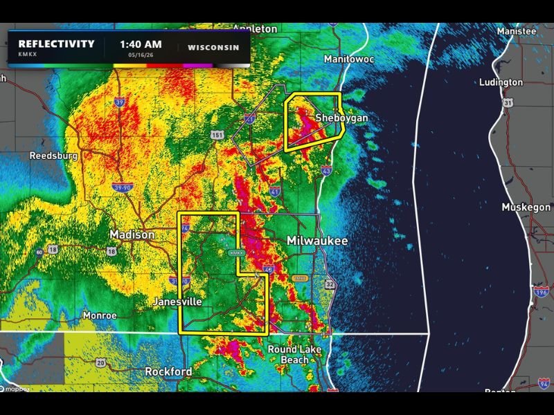
Radar imagery captured at 1:40 AM from the KMKX Milwaukee radar site shows a broad and expansive storm complex stretching across a large portion of Wisconsin, with intense red and yellow reflectivity returns concentrated in a north to south oriented band directly approaching the Milwaukee metropolitan area. Despite a general weakening trend as the storms move east, the lightning activity associated with this system remains extremely active and dangerous across the entire affected corridor.
The storm complex extends from the Madison and Janesville areas northward through the Milwaukee metro and further northeast toward Sheboygan, covering a substantial swath of southeastern Wisconsin with ongoing storm activity through the early morning hours.
Active Warning Polygons Cover Milwaukee Janesville and Sheboygan Corridors
Yellow warning polygons visible on radar maps outline active severe weather areas covering three distinct zones including the greater Milwaukee area, the Janesville corridor to the southwest, and a separate polygon covering the Sheboygan area to the north along Lake Michigan. These active warning zones indicate that despite the overall weakening trend of the storm complex, localized threats remain significant enough to warrant continued warnings across these specific communities.
Residents within all three outlined warning polygons should remain sheltered and weather aware as the storms continue their eastward progression toward the Lake Michigan shoreline during the overnight hours.
Gusty Winds Remain Possible as Storms Push Into Milwaukee and Surrounding Areas
Although the most intense severe characteristics of this storm system have diminished on approach to Milwaukee, gusty winds remain a credible threat as the line moves through the metro and surrounding communities. Wind gusts accompanying weakening but still active storm lines can remain dangerous and capable of downing tree limbs and causing localized power outages even as overall storm intensity decreases.
Residents across Milwaukee, Janesville, Sheboygan, and all communities within the active warning polygons are urged to remain indoors and away from windows until the storm complex fully clears the area and all active warnings are officially lifted by the National Weather Service.
For continuing coverage of severe weather warnings and overnight storm tracking across the United States, visit SaludaStandard-Sentinel.com.