Extreme Storm Energy Targets Oklahoma and North Texas Monday With Strong Tornadoes Large Hail and Damaging Winds Expected Through Overnight
OKLAHOMA CITY, OK — Monday carries the greatest potential for widespread significant severe weather across parts of Oklahoma and North Texas as an extremely unstable airmass builds across the Southern Plains. A strengthening jet stream combined with a strong disturbance ejecting into the region and an advancing cold front are collectively supporting conditions capable of producing supercells and bowing storm clusters from late afternoon through the overnight hours.
Extreme Atmospheric Instability Sets the Stage for a Dangerous Monday
Forecast guidance indicates an exceptionally unstable airmass is expected to be in place across Oklahoma and North Texas by Monday, providing the fuel necessary for intense and long-lived storm development. The combination of extreme storm energy, a strengthening jet stream, and a strong upper level disturbance moving into the Southern Plains creates a highly favorable environment for organized and significant severe weather across the entire affected corridor.
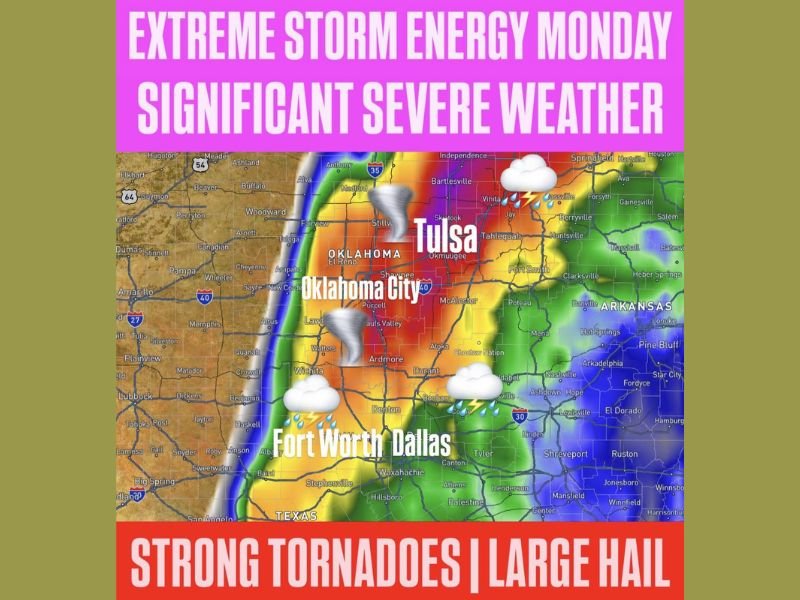
The threat area encompasses a broad zone stretching from central and southern Oklahoma southward through the Dallas and Fort Worth metroplex in North Texas. Oklahoma City, Tulsa, Ardmore, Denton, and surrounding communities all fall within the highest risk zone as Monday’s setup continues to come into sharp focus.
Strong Tornadoes and Very Large Hail Headline the Monday Threat
The primary hazards associated with Monday’s severe weather setup include strong tornadoes, very large hail, and widespread damaging winds. Supercell thunderstorms are expected to be capable of producing all three hazard types, with the tornado and large hail threats particularly concerning given the extreme instability and wind shear profiles forecast across the region during the late afternoon and evening hours.
Bowing storm clusters capable of producing widespread damaging winds are also possible as the cold front pushes through overnight, extending the severe weather threat well beyond the initial afternoon storm initiation and deep into the overnight hours for communities across Oklahoma and North Texas.
Oklahoma City and Tulsa Among the Most Closely Watched Metro Areas
The Oklahoma City and Tulsa metropolitan areas sit directly within the core of the highest risk zone for Monday’s severe weather outlook. Both cities and their surrounding communities face the full spectrum of severe weather hazards, with the tornado threat making this setup especially dangerous for a densely populated corridor spanning central and eastern Oklahoma.
Residents across Oklahoma City, Tulsa, and all surrounding communities are urged to have multiple ways to receive severe weather warnings, know their shelter locations in advance, and remain actively weather-aware from late afternoon through the overnight period as storms develop and move through the region.
North Texas Communities From Fort Worth to Dallas Also Face Significant Risk
The severe weather threat extends southward into North Texas, placing Fort Worth, Dallas, and surrounding communities within the significant severe weather zone for Monday. The southward reach of the risk area reflects the broad scope of the unstable airmass and the cold front’s anticipated track across the Southern Plains throughout the day and into the night.
Residents across all communities within the outlined threat zones are encouraged to prepare now, monitor updated forecasts closely, and have a clear severe weather action plan in place well before Monday’s storm potential arrives. For continuing coverage of severe weather threats and critical storm forecasts across the United States, visit SaludaStandard-Sentinel.com.