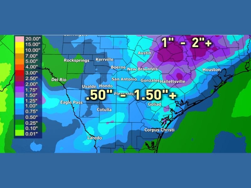
NOAA Weather Prediction Center Seven Day Rainfall Forecast Shows Half Inch to Over Two Inches Expected Across South and Central Texas With Rain Chances Extending Beyond the Forecast Window
SAN ANTONIO, TX — NOAA’s Weather Prediction Center has issued a seven day rainfall forecast for South and Central Texas showing widespread precipitation totals ranging from 0.50 inches to 1.50 inches or more across a broad portion of the region. Higher totals of one inch to two inches and above are projected across portions of Central Texas including the Austin and Houston corridors, with rain chances expected to extend well beyond the seven day forecast window.
Widespread Half Inch to One and a Half Inch Totals Forecast Across South Texas
The seven day rainfall forecast map shows blue shading dominating the majority of South and Central Texas, indicating general totals in the 0.50 inch to 1.50 inch range across communities including San Antonio, Uvalde, Hondo, Pleasanton, Goliad, Kerrville, and New Braunfels. These totals represent meaningful rainfall for a region that has experienced dryness in recent weeks and would provide beneficial relief to drought stressed soils across the area.
Areas further south including Laredo, Eagle Pass, Cotulla, and Corpus Christi fall within lighter shading on the forecast map, suggesting more modest rainfall accumulations are expected across the southern tip of the region over the same seven day period.
Central Texas and Houston Corridor Poised for the Heaviest Accumulations
The highest rainfall totals in the forecast are concentrated across Central Texas and extending eastward toward the Houston metropolitan area, where purple shading on the WPC map indicates projected totals of one inch to two inches or more. The Austin corridor sits within this heavier rainfall zone, as does a broad swath of territory stretching southeast toward Houston and Hallettsville.
These elevated totals across Central and Southeast Texas reflect the influence of deep Gulf moisture pushing inland combined with an active frontal pattern expected to drive multiple rounds of rainfall through the region over the coming week.
Rain Chances Expected to Continue Beyond the Seven Day Window
Forecasters note that rainfall chances are not limited to the seven day forecast period currently depicted, with additional precipitation opportunities likely to extend into the following week as the unsettled pattern persists across Texas. This extended rainfall potential adds to the overall accumulation picture and suggests total rainfall across the region could ultimately exceed what the current seven day map reflects.
The prolonged nature of this wet pattern is particularly significant for communities and agricultural areas across South and Central Texas that have been monitoring soil moisture and water supply conditions closely heading into the latter half of May.
For continuing coverage of rainfall forecasts and active weather patterns across the United States, visit SaludaStandard-Sentinel.com.