Rain Thunderstorms and Mountain Snow to Seattle and Western Washington Friday and Saturday With Snow Levels Dropping to 3500 Feet and 6 to 8 Inches on Higher Peaks
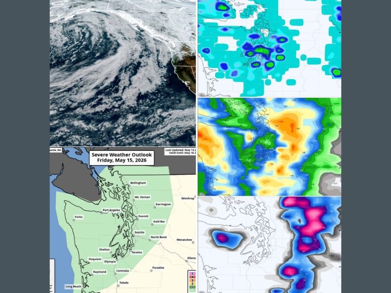
SEATTLE, WA — Two back-to-back Pacific troughs are set to roll through Western Washington on Friday and Saturday, delivering rain, a slight thunderstorm risk on both days, and significant mountain snow with levels dropping to 3,500 to 4,000 feet by Saturday into early Sunday, as Seattle continues one of its most weather-whiplash weeks in recent memory following a stunning 24-degree temperature drop in just 24 hours earlier this week.
Seattle’s Wild Week Sets the Stage
Seattle’s weather this week has run the full gamut, opening with a comfortable 72-degree Monday before Tuesday tied a record high at 82 degrees, only for Wednesday to crash temperatures down to 58 degrees alongside rain and isolated thunder — a remarkable 24-degree drop within a single 24-hour period.
Thursday offers a brief break with a few isolated morning showers and highs clawing into the low to mid 60s before the next active stretch arrives Friday. After 13 consecutive days without rain before Tuesday’s showers, the region can certainly use the upcoming wet pattern.
Friday Trough Brings Rain With Slight Thunderstorm Risk
The first of the two troughs arrives Friday, bringing rain at times across Western Washington with a slight thunderstorm risk that NOAA’s Storm Prediction Center highlighted by placing much of Western Washington under its general thunderstorm risk category in the Severe Weather Outlook valid May 15, 2026.
Friday’s thunderstorm risk is characterized as quite slight, but residents across the Seattle, Tacoma, Everett, and surrounding Puget Sound communities should remain aware of the possibility. Combined rainfall totals from both Friday and Saturday systems are forecast at approximately 0.30 to 0.50 inches across the Puget Sound lowlands.
Saturday’s Stronger Trough Increases Snow and Storm Threat
Saturday’s second trough carries more atmospheric instability due to cooler air aloft, increasing the thunderstorm potential compared to Friday, particularly across Convergence Zone areas north of Seattle. Snow levels will drop to 3,500 to 4,000 feet by Saturday into early Sunday, with models showing a couple of inches of wet snow at mid altitudes and 6 to 8 inches along the higher Cascade peaks.
Hikers and campers heading into the Cascades this weekend should prepare for rain Friday, then rain or wet snow and possible thunderstorms Saturday before conditions dry out Saturday night ahead of a mostly sunny next week.
For continuing coverage of severe weather events and critical storm analysis across the United States, visit SaludaStandard-Sentinel.com.