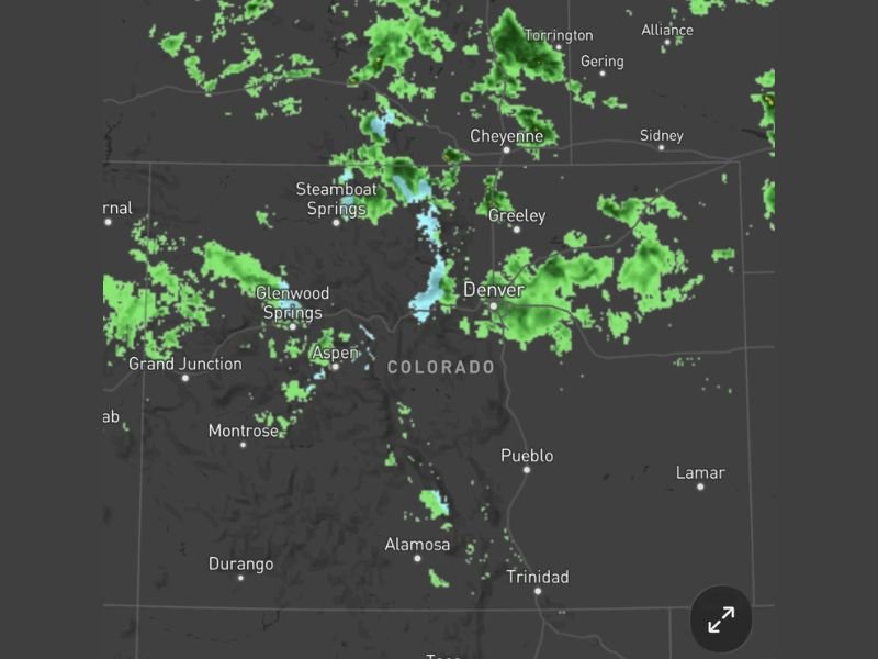
Widespread Rain Showers Confirmed Falling Across Colorado With Radar Showing Active Coverage From Denver and Greeley Through Steamboat Springs Aspen and Into Southern Wyoming Border
DENVER, CO — Radar confirms widespread rain showers actively falling across a broad stretch of Colorado, with precipitation returns visible from the Denver and Greeley metro corridor westward through Steamboat Springs, Glenwood Springs, and Aspen, while additional shower activity extends northward toward the Wyoming border communities of Cheyenne, Torrington, and Gering.
Rain Confirmed Falling Across Wide Colorado Coverage Area
Radar imagery shows an extensive network of shower activity blanketing a significant portion of Colorado, with green returns indicating confirmed rainfall across multiple regions of the state simultaneously. The coverage stretches from the eastern plains near Denver and Greeley westward through the central mountain corridor, representing a notably broad precipitation footprint across a state that frequently contends with dry conditions during periods of building heat and high pressure dominance.
The shower activity appears widespread rather than isolated, suggesting a meaningful precipitation event delivering measurable rainfall across both urban Front Range communities and mountainous interior regions of the state.
Mountain Zones Seeing Mixed Precipitation
Radar returns across the higher elevation zones near Steamboat Springs, Glenwood Springs, and Aspen show blue-tinted signatures indicative of snow or mixed precipitation at altitude, consistent with the cooler temperatures that persist across Colorado’s mountain terrain even as lower elevations receive rainfall. The Aspen and Steamboat Springs corridors, sitting at significantly higher elevations than the Front Range, are likely receiving a wintry mix or periods of mountain snow alongside the broader rain event affecting the state.
This mixed precipitation signal across the high country adds additional snowpack value to mountain zones that benefit from late-season moisture accumulation well into May.
Shower Activity Extends Into Southern Wyoming
Beyond Colorado’s borders, radar shows shower returns pushing northward into the southern Wyoming communities of Cheyenne, Torrington, Gering, and Alliance, indicating that the precipitation system responsible for the Colorado rainfall extends across a broader regional footprint. The Cheyenne area in particular shows moderate shower returns, suggesting measurable rainfall is occurring across the state line communities simultaneously with the Colorado event.
This cross-border coverage highlights the regional scope of the moisture pattern currently delivering precipitation across the central High Plains and Rocky Mountain corridor.
Welcome Moisture for a Drought-Prone Region
Rainfall events of this nature carry considerable value for Colorado and the surrounding High Plains region, where water resources, agricultural land, and wildfire risk are all directly influenced by precipitation frequency and totals during the spring months. Any confirmed, measurable rainfall across a broad swath of the state represents a beneficial moisture input for a region that frequently faces dry and fire-prone conditions as summer approaches.
For continuing coverage of severe weather events and critical storm analysis across the United States, visit SaludaStandard-Sentinel.com.