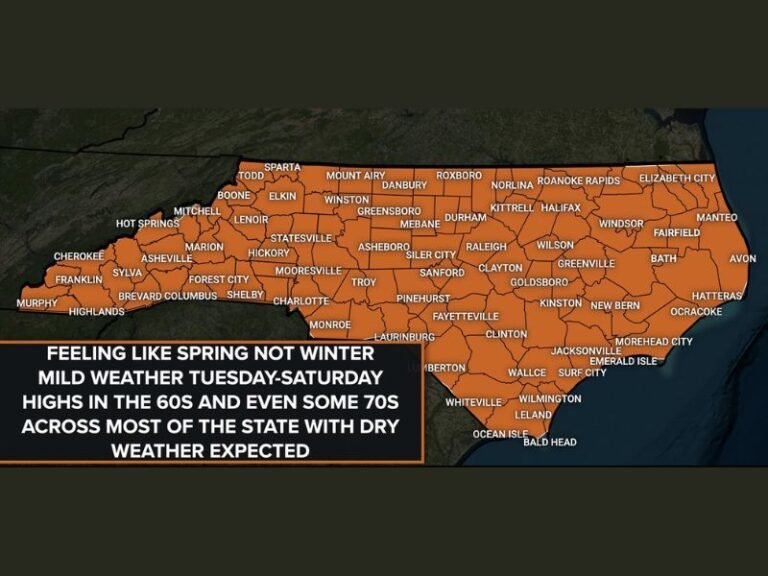
Cold Front Pushes South Across the Carolinas Dropping Temperatures and Gusting Winds to 25 MPH Overnight With Best Rain Chances Targeting the Border Belt Region From Florence to Fayetteville
FAYETTEVILLE, NC — A cold front is actively pushing southward across the Carolinas as of the 9 PM radar update, bringing a notable wind shift to northerly directions with gusts reaching around 25 miles per hour, a measurable temperature drop in its wake, and scattered shower activity that gives the Border Belt region the best chances of overnight rainfall while the entire surrounding area retains a small but real chance of rain through the night.
Cold Front Tracking South Across the Region
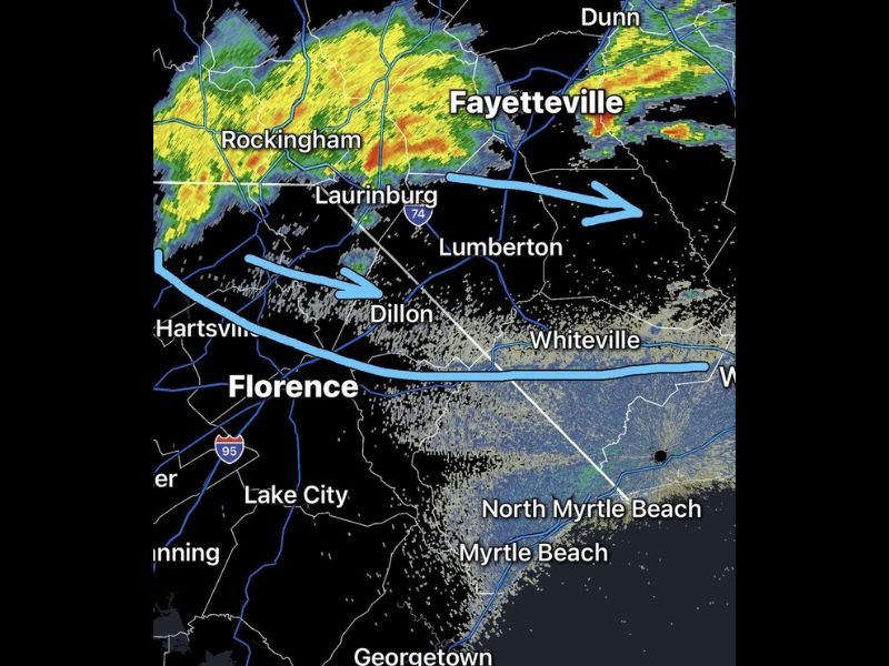
Radar imagery from the 9 PM update clearly depicts the cold front as a defined boundary pushing southward across the Carolinas, shown as a blue line sweeping through the region from the Rockingham and Laurinburg corridor eastward toward Lumberton and beyond. Shower activity is concentrated along and ahead of the frontal boundary, with the most intense radar returns visible over Rockingham and extending toward Fayetteville and Dunn in the northern portion of the radar frame.
As the front continues its southward progression through the overnight hours, the shower line will advance accordingly, dragging cooler and drier air in behind it across communities from Florence and Lake City northward through Dillon, Lumberton, and Whiteville.
Wind Shift and Temperature Drop to Follow Frontal Passage
As the cold front passes through each community, winds will shift to a northerly direction and gust to approximately 25 miles per hour, a noticeable change from the southerly flow that typically precedes frontal passages across the Carolinas. This wind shift will be one of the most immediately felt indicators of the front’s arrival for residents across the region during the overnight hours.
Temperatures will drop measurably behind the frontal boundary as cooler air replaces the warmer airmass currently in place ahead of the system. Residents who have grown accustomed to mild overnight temperatures in recent days should expect a noticeably cooler feel by morning across the entire affected corridor.
Border Belt Holds Best Rain Chances Tonight
While the entire region carries a small chance of rain overnight, forecasters identify the Border Belt as holding the best rain chances through the evening and overnight period. This zone, spanning communities including Florence, Dillon, Laurinburg, and the surrounding agricultural corridor straddling the North and South Carolina state line, sits directly in the path of the frontal boundary and trailing shower activity, giving it the highest probability of receiving measurable precipitation before conditions clear behind the front.
Communities further removed from the frontal track, including Myrtle Beach, North Myrtle Beach, Georgetown, and coastal areas, carry lower but still nonzero rain probabilities through the overnight period.
Clearing Conditions Expected Behind the Front
Once the cold front completes its passage through the region, clearing conditions are expected to follow as the drier northerly flow takes hold across the Carolinas. Residents across Florence, Fayetteville, Lumberton, and surrounding communities should anticipate noticeably cooler and calmer conditions by morning as the frontal system exits the area and high pressure begins to build in behind it overnight.
For continuing coverage of severe weather events and critical storm analysis across the United States, visit SaludaStandard-Sentinel.com.