Heat Builds Across Western Two-Thirds of the United States From May 13 to 17 as Ridge Pattern Creates Unfavorable Conditions for Large Scale Severe Weather and Tornado Outbreaks
CENTRAL UNITED STATES — A strengthening ridge of high pressure is driving a significant heat buildup across the western two-thirds of the lower 48 states between May 13 and May 17, creating a temperature pattern that simultaneously suppresses the atmospheric flow necessary for large-scale severe weather and tornado outbreaks, even as low-end daily severe weather chances persist across portions of the country through the summer months ahead.
Heat Dominating the Western and Central United States
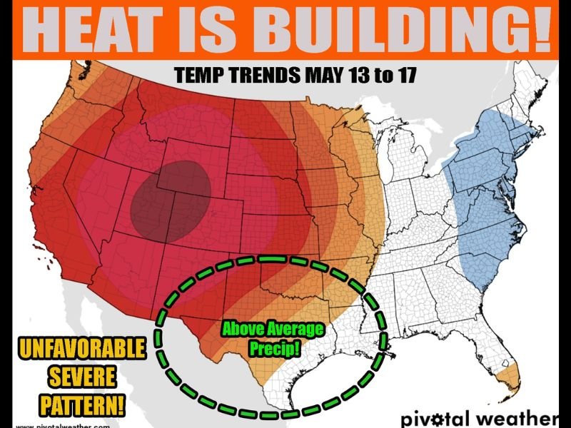
Temperature trend forecasts from Pivotal Weather clearly depict an intense and expansive warm anomaly centered across the western United States and extending through the central plains, with the deepest above-normal temperature readings concentrated across the Southwest, Mountain West, and into the central portions of the country. The heat signal is particularly pronounced across the western core of the nation, where temperatures are expected to run well above seasonal averages throughout the May 13 to 17 timeframe.
This building heat dome is being driven by a strengthening ridge in the west, which is causing atmospheric flow to slow significantly or disappear altogether across broad portions of the lower 48.
Pattern Unfavorable for Large Scale Severe Weather
The developing ridge pattern carries important implications for severe weather potential across the United States during this period. When a strong western ridge dominates the pattern and atmospheric flow slows, the large-scale wind shear and dynamic forcing mechanisms necessary to fuel significant tornado outbreaks and widespread severe weather events become increasingly difficult to sustain.
Forecasters note that the overall setup is unfavorable for large-scale severe and tornado outbreak events, offering a relative respite from the more dangerous atmospheric configurations that have driven recent severe weather activity across the South and central United States.
Low End Daily Chances Remain Across the Country
Despite the broadly suppressed severe weather pattern, forecasters are clear that severe weather never completely shuts down during the warm months. The Storm Prediction Center has outlined Level 1 marginal risk areas for the next three days, a designation expected to become a near-daily occurrence across some portion of the country as summer approaches.
All that is required for isolated severe weather development is sufficient heat, moisture, and even minimal atmospheric flow — ingredients that remain available across portions of the country even within a suppressed large-scale pattern.
Northeast Stays Cool While South Sees Above Average Precipitation
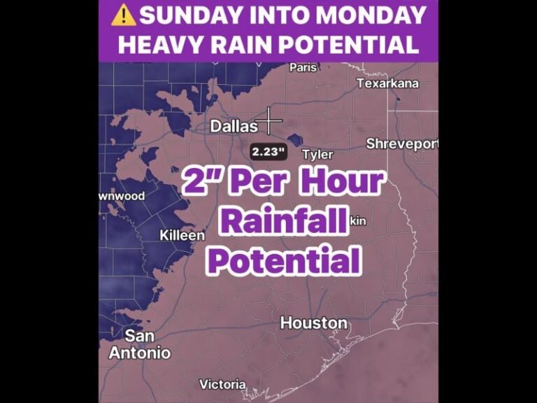
While heat dominates the western and central portions of the nation, the northeastern United States is forecast to remain notably cooler than average through the May 13 to 17 period, with below-normal temperature signals across the mid-Atlantic and New England states. Additionally, a zone across the south-central United States is highlighted for above-average precipitation during this same timeframe, indicating that while severe outbreak potential is limited, rainfall activity will continue across portions of the Gulf Coast and southern plains regions.
For continuing coverage of severe weather events and critical storm analysis across the United States, visit SaludaStandard-Sentinel.com.