Tornadoes Large Hail and Damaging Winds Strike Texas, Oklahoma, Arkansas, Missouri, Mississippi, Tennessee, Kentucky, and Illinois While Colorado and Wyoming Face 10 to 24 Inch Snow Tuesday
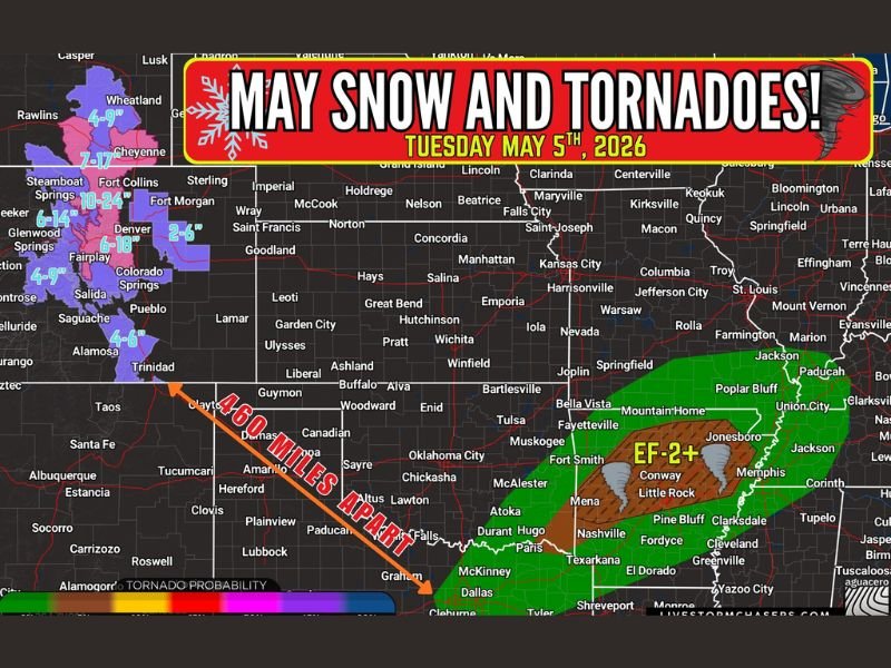
THE MID SOUTH AND ROCKIES — One of the most meteorologically unusual severe weather setups of the 2026 spring season unfolded on Tuesday, May 5, 2026, as EF-2 or greater tornado potential threatened eight states across the Mid South simultaneously while Colorado, Wyoming, and the Rocky Mountains faced 10 to 24 inches of heavy snow just 460 miles away in the same weather system.
The tornado probability zone stretched across a broad corridor covering Texas, Oklahoma, Arkansas, Missouri, Mississippi, Tennessee, Kentucky, and Illinois, with the highest EF-2 plus tornado potential concentrated across central and northeast Arkansas through the Memphis and Conway corridor.
Eight States Face Tornado Large Hail and Damaging Wind Threat
The severe weather side of the Tuesday system threatened tornadoes, large hail, and damaging winds across all eight states within the outlined risk zone. The highest tornado probability was focused across the Arkansas corridor including Fort Smith, Conway, Little Rock, Jonesboro, and Pine Bluff, extending northeastward through Memphis, Nashville, and into the western Kentucky and southern Illinois region.
The EF-2 plus designation across the core risk zone indicated the potential for violent and significantly damaging tornado development across communities positioned within the highest probability corridor during the Tuesday afternoon and evening timeframe.
Colorado and Wyoming Face Up to 24 Inches of Snow
Just 460 miles to the northwest, an entirely different weather story was developing across Colorado and Wyoming. Denver and surrounding Front Range communities faced 2 to 6 inches of snow while the Rocky Mountain terrain from Steamboat Springs and Fort Collins through Glenwood Springs and Salida was forecast to receive 10 to 24 plus inches of heavy wet snow, bringing slushy road conditions and significantly reduced visibility across mountain travel corridors.
Cheyenne, Wyoming was also included in the snow footprint with 7 to 17 inches expected, making the simultaneous tornado and blizzard conditions unfolding across two regions of the central United States one of the most dramatic spring weather contrasts of the season.
For continuing coverage of severe weather events and critical storm analysis across the United States, visit SaludaStandard-Sentinel.com.