Heavy Rain and Storm System Dropping South Across Oklahoma Overnight Targeting Dallas, Fort Worth, and North Texas as Cold Front Races In
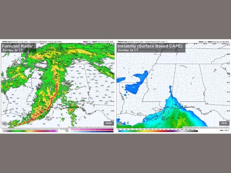
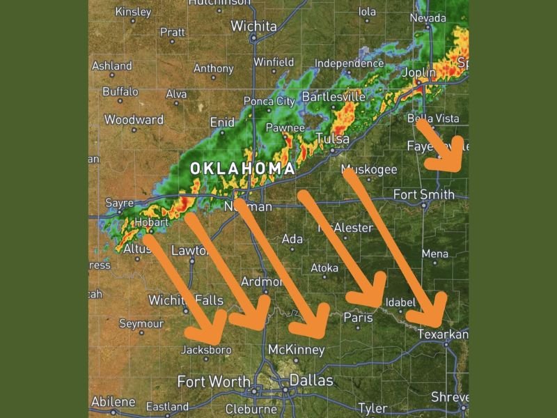
OKLAHOMA AND TEXAS — A large and organized area of rain and storms was dropping southward across Oklahoma at 10:15 PM Central Friday, April 17, 2026, with the entire system expected to continue pushing south overnight and eventually moving into Texas as a cold front races in from the northwest. Radar imagery showed an intense band of precipitation stretching from the Altus and Hobart area eastward through Norman, Tulsa, Bartlesville, and toward Joplin, with multiple orange arrows on forecast graphics pointing directly southward toward Dallas, Fort Worth, and the broader North Texas region.
The storm system was actively impacting communities across central and eastern Oklahoma at the time of the update, with the heaviest precipitation cores concentrated along a line from Altus through Norman and into the Tulsa corridor.
Storm System Tracking Southward Toward Texas Overnight
The primary concern with Friday night’s storm system is its steady southward progression driven by the advancing cold front pushing in from the northwest. Unlike storm systems that move quickly through an area, this system was expected to continue dropping south through the overnight hours, meaning communities across southern Oklahoma including Lawton, Ardmore, Ada, Atoka, McAlester, and Idabel will all experience the rain and storms as they push through during the late night hours.
The system’s track points directly toward the Dallas and Fort Worth metroplex, with communities including McKinney, Jacksboro, and surrounding North Texas areas positioned in the direct path of the overnight storm progression.
Cold Front Accelerating the Southward Push
The cold front racing in from the northwest is the primary driving force pushing this large rain and storm complex southward through Oklahoma and into Texas overnight. As the front advances, it is effectively scooping the existing storm complex and pushing it progressively further south, ensuring that the rain and storm activity continues spreading into new areas rather than weakening and dissipating over Oklahoma.
Communities along the Red River region including Wichita Falls, Paris, and Texarkana are also positioned to receive rainfall from this system as it tracks southward through the overnight hours toward the Texas border.
What Oklahoma and Texas Residents Should Expect Overnight
Residents across southern Oklahoma and North Texas should expect the rain and storm complex to arrive during the overnight hours, with timing varying depending on exact location relative to the system’s southward progression. While the primary severe weather threat from Friday’s earlier outbreak has diminished, heavy rainfall and active thunderstorms remain possible with this overnight system as the cold front drives it southward.
Residents in Dallas, Fort Worth, and surrounding North Texas communities should ensure weather alerts are active before going to sleep Friday night, as the storm complex is expected to push into the region during the early morning hours Saturday.
Are you tracking the overnight storm system across Oklahoma or North Texas? Share your updates and stay connected at SaludaStandard-Sentinel.com.