Showers and Thunderstorms Arriving Across North Texas and Dallas Metroplex by 4 AM Saturday as Overnight Cold Front Pushes Rain Into Central Texas by Noon
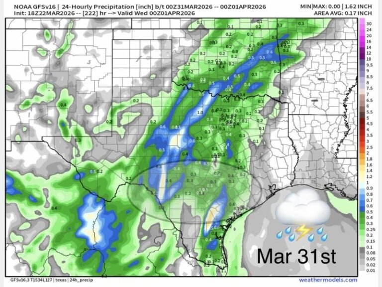
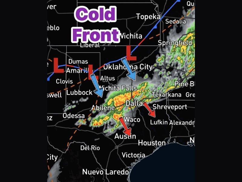
NORTH TEXAS — An overnight cold front is sweeping southward into North Texas, expected to arrive across the Dallas-Fort Worth metroplex by 4 AM Saturday morning, bringing a round of showers and a few thunderstorms to the region before additional rain develops behind the frontal boundary. The front is tracking from the Oklahoma border southward through Wichita Falls and Dallas toward Central Texas, with radar showing a well-organized band of precipitation pushing steadily south along the frontal boundary.
Forecasters confirmed that no severe weather is expected with this system, offering residents some reassurance after a week dominated by dangerous and intense storm activity across the broader region.
Dallas Metroplex Rain Window 4 AM to 10 AM
The primary rain window for the Dallas-Fort Worth metroplex runs from 4 AM through 10 AM Saturday morning as the cold front pushes through and additional showers develop in its wake. Coverage data supports approximately 60 percent of the metroplex seeing measurable rainfall during this window, while roughly 40 percent of locations may see little to nothing at all depending on exact storm placement.
Rain amounts across the metroplex are forecast at 0.25 to 0.50 inches for most locations, with some isolated higher totals possible where heavier showers or thunderstorm cells produce brief periods of intense rainfall during the morning hours.
Rain Pushes Into Central Texas by Noon
After clearing the Dallas-Fort Worth area by around 10 AM, the rain associated with the cold front will continue pushing southward into Central Texas, reaching communities including Waco, Austin, and surrounding areas by noon Saturday. This southward progression means residents in Central Texas will see their rain chance arrive during the late morning to early afternoon hours rather than the overnight timing affecting North Texas.
Communities along the Interstate 35 corridor from Dallas through Waco and into Austin should keep rain gear handy for Saturday morning plans, as wet conditions will accompany the frontal passage through the midday hours before gradually improving.
Clearing Skies Expected Saturday Afternoon
Behind the cold front, overcast skies will linger across much of Texas through the morning hours before sunshine gradually returns during the late afternoon hours Saturday. This means the second half of Saturday should see improving conditions across both North and Central Texas as the frontal system pushes further south and east.
Residents in the Amarillo, Lubbock, Odessa, and West Texas communities are also being impacted by the front’s approach, with the dryline and low pressure centers positioned across the Texas Panhandle region driving the overall weather pattern southward through the weekend.
Are you tracking Saturday morning’s cold front across the Dallas metroplex or Central Texas? Share your conditions and stay connected at SaludaStandard-Sentinel.com.