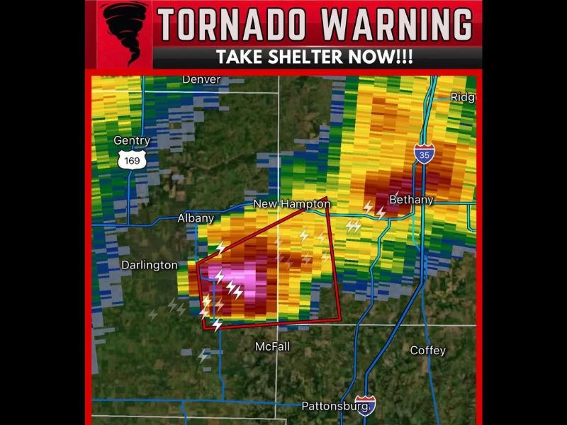
Tornado Warning Issued for Northwest Missouri Near Albany as Tornado Capable Storm Moves Northeast at 20 MPH Threatening New Hampton and Bethany Communities
ALBANY, MO — A tornado warning was issued for northwestern Missouri after a severe thunderstorm capable of producing a tornado was located 7 miles southeast of Albany, moving northeast at 20 miles per hour and placing multiple Gentry and Harrison county communities including New Hampton, Bethany, and Darlington under an immediate take shelter directive as radar imagery showed an extraordinarily intense and alarming storm core with deep magenta reflectivity values concentrated within the active warning polygon.
Radar Presentation Signals Extreme Danger
Radar imagery captured during the active tornado warning shows one of the most visually alarming storm core presentations possible across the northwestern Missouri landscape, with deep magenta and purple reflectivity values concentrated directly within the red tornado warning polygon southeast of Albany and tracking northeastward toward New Hampton and the Bethany corridor along Interstate 35.
The intensity of the reflectivity values within the warning polygon combined with the prolific lightning activity visible throughout the storm core reflects the exceptional organization and energy of this tornadic thunderstorm cell as it tracks through the sparsely populated but agriculturally significant landscape of northwestern Missouri during the active warning period.
Warning Polygon and Communities in the Threat Zone
The tornado warning polygon as drawn on radar encompasses a focused corridor stretching from southeast of Albany and Darlington northeastward through New Hampton and toward Bethany along the Interstate 35 corridor, placing all residents within these boundaries under an immediate and potentially life-threatening tornado threat.
Bethany, the Harrison County seat located along Interstate 35, sits directly within or immediately adjacent to the northeastern edge of the warning polygon, placing a significant community population in the direct path of the storm’s projected northeastward track at its 20 mile per hour movement speed during the valid warning period.
Additional Communities on Alert
Communities surrounding the primary warning corridor including Gentry along Highway 169, Denver, McFall, Pattonsburg, Coffey, and Jameson in the broader northwestern Missouri region are advised to remain weather aware and prepared to take immediate shelter as the storm continues tracking northeast through the active warning area.
The storm’s movement along the Interstate 35 corridor creates additional hazard for motorists traveling the highway during the warning period, with all drivers urged to exit the highway immediately and seek substantial shelter in a nearby permanent structure rather than attempting to outrun the storm in a vehicle.
For continuing coverage of Missouri tornado warnings and severe weather emergencies across the United States, visit SaludaStandard-Sentinel.com.