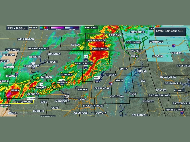
Strong Thunderstorms Tracked North and West of Tulsa Oklahoma Friday Night With 533 Lightning Strikes Recorded and Severe Cells Closing In
OKLAHOMA — Strong thunderstorms were being actively tracked across northeastern Oklahoma at 8:30 PM Friday, April 17, 2026, with radar showing intense storm activity north of Tulsa while forecasters kept a close eye on severe thunderstorms developing west of the city and additional cells approaching the area. Radar data recorded an impressive 533 total lightning strikes from the storm complex, underscoring the significant electrical activity accompanying Friday night’s storm system across the region.
Radar reflectivity imagery captured at 8:33 PM showed the most intense storm cores positioned across the Bartlesville, Coffeyville, and Independence corridor north of Tulsa, with additional activity visible across the Ponca City, Stillwater, and Perry areas to the northwest.
Storm Activity North of Tulsa Being Monitored
The strongest storm activity at the time of the 8:30 PM update was located north of Tulsa, stretching from the Bartlesville area northward through Coffeyville and into the southeastern Kansas communities of Independence and Parsons. While forecasters confirmed that storm activity north of Tulsa had not yet reached severe levels at the time of the update, the intensity of the radar returns and the high lightning strike count warranted close and continuous monitoring throughout the evening.
Communities including Bartlesville, Wynona, Claremore, Chelsea, Vinita, and surrounding northeastern Oklahoma towns were all positioned within or near the active storm zone as Friday night’s weather event continued developing across the region.
Severe Cells West of Tulsa Raising Concern
Beyond the storm activity already north of the city, forecasters expressed particular concern about severe thunderstorms developing west of Tulsa and tracking toward the metro area. This secondary threat represented a potentially more dangerous situation for Tulsa residents, as these storms were still approaching and had the potential to intensify further before reaching the city.
Additional storm cells were also entering the broader viewing area from the northwest, adding another layer of complexity to an already active severe weather night across northeastern Oklahoma and the Tulsa metro region.
What Residents Across the Region Should Do
With strong to potentially severe thunderstorms approaching from multiple directions, residents across the Tulsa metro and surrounding communities in northeastern Oklahoma should remain indoors with weather alerts active throughout the Friday evening hours. The combination of 533 recorded lightning strikes and radar-indicated storm intensity means that outdoor exposure carries significant risk even from storms that have not yet reached official severe criteria.
Residents in Bartlesville, Claremore, Broken Arrow, and surrounding communities should monitor conditions closely and be prepared to take shelter immediately if a severe thunderstorm or tornado warning is issued for their specific county.
Were you tracking Friday night’s storm activity across Tulsa or northeastern Oklahoma? Share your observations and stay connected at SaludaStandard-Sentinel.com.