Cold Front Colliding With Warm Humid Air Bringing Thunderstorms and Damaging Winds Across the Southeast and Mid-Atlantic Early Sunday Morning
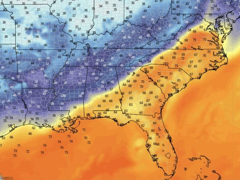
SOUTHEAST AND MID-ATLANTIC — A significant cold front is set to collide with warm and humid air across the Southeast and Mid-Atlantic regions early Sunday morning, producing a sharp and dramatic clash of air masses that forecasters warn will generate thunderstorms, strong winds, and rapidly changing conditions that could catch residents off guard. Temperature forecast maps showed a striking contrast across the region, with warm air readings in the 60s and 70s across the Southeast meeting cold air temperatures in the upper 30s and 40s pushing down from the north.
The frontal boundary is expected to produce its most impactful conditions during the early morning hours Sunday, meaning many residents could wake up to suddenly deteriorating weather after a seemingly calm start to the day.
Sharp Temperature Contrast Fueling Storm Development
The temperature contrast visible across the forecast map tells the story of why Sunday morning’s weather will be so dramatic. Across the Deep South and coastal Southeast, temperatures are holding in the 60s to mid-70s with warm and humid conditions, while the advancing cold air mass is pushing temperatures into the upper 30s and low 40s across the northern tier of the affected region.
This sharp temperature gradient concentrated along the frontal boundary is precisely the atmospheric fuel needed to generate intense thunderstorm development as the two dramatically different air masses collide during the early morning hours across the region.
Thunderstorms and Damaging Winds the Primary Threats
The primary threats accompanying Sunday morning’s frontal passage are thunderstorms and damaging winds capable of sending outdoor furniture airborne and causing property damage across affected communities. The rapid nature of the frontal passage means conditions could shift from calm to severe within a very short window, giving residents minimal time to react if they are not already weather-aware when the front arrives.
Residents with outdoor furniture, decorations, or unsecured items should bring everything inside Saturday evening before the front arrives overnight, as strong wind gusts accompanying the frontal boundary could cause significant damage to anything left outside.
What Residents Should Do Before Sunday Morning
Anyone with outdoor plans for early Sunday morning should monitor local weather conditions closely and be prepared for a rapidly changing situation as the cold front pushes through. Keep weather alert notifications active overnight Saturday so any warnings issued during the early morning hours reach you immediately rather than being discovered after the fact.
Behind the frontal passage, significantly cooler temperatures will settle in across the region as the cold air mass replaces the warm and humid conditions, bringing a noticeably different feel to Sunday afternoon compared to the warmth experienced earlier in the weekend.
Are you preparing for Sunday morning’s cold front passage across the Southeast or Mid-Atlantic? Share your plans and stay connected at SaludaStandard-Sentinel.com.